Ungava Bay facts for kids
Quick facts for kids Ungava Bay |
|
|---|---|

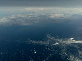
Aerial view of north-eastern Ungava Bay close to Cape Chidley, seen from north-west towards south-east. In the foreground is drift-ice, in mid-July.
|
|
 |
|
| Location | Hudson Strait |
| Coordinates | 59°30′N 67°15′W / 59.500°N 67.250°W |
| Basin countries | Canada |
| Max. length | 320 km (200 mi) |
| Max. width | 260 km (160 mi) |
| Surface area | c. 50,000 km2 (19,000 sq mi) |
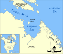
Ungava Bay is a large bay in northeastern Canada. It separates Nunavik (which is the northern part of Quebec) from Baffin Island. Even though it looks like it's part of the Atlantic Ocean, it's actually considered a small part of the Arctic Ocean. This is because of its climate.
The bay is shaped a bit like an oval. It's about 260 km (160 mi) wide and 320 km (200 mi) long. Its total area is around 50,000 km2 (19,000 sq mi). Ungava Bay is usually quite shallow, less than 150 m (490 ft) deep. But near where it meets the Atlantic Ocean, the water can be almost 300 m (980 ft) deep.
Contents
Exploring Ungava Bay's Geography
Ungava Bay is very close to the open Atlantic Ocean. Only the Hudson Strait separates them. The Ungava Peninsula separates Ungava Bay from Hudson Bay.
Many islands are found in Ungava Bay. The biggest one is Akpatok Island. Scientists have studied the bottom of the bay. Some think Ungava Bay might be what's left of a very old impact crater. This crater would have been about 225 km (140 mi) across.
Amazing Tides in Ungava Bay
The southwestern part of Ungava Bay has some of the highest tides in the world. It's often compared to the Bay of Fundy in Nova Scotia. At the mouth of the Leaf River, the water level can change by as much as 17 m (56 ft) during a spring tide. That's taller than a four-story building!
People have tried to use these powerful tides to create electricity. This is called tidal power. However, it's very hard to do because the weather is so harsh. Also, the bay is only free of ice for a short time each year.
Understanding Ungava Bay's Climate
The weather around Ungava Bay is very cold. This is because of the Labrador Current, which is a cold ocean current. Summers are too cold for trees to grow here. All the land around the bay is tundra, which is a treeless plain.
For example, in Kuujjuaq, a town near the bay, summer temperatures are usually around 7 °C (45 °F). In winter, temperatures drop to about −20 °C (−4 °F). The area gets about 400–450 mm (16–18 in) of rain and snow each year. Most of this falls during the summer months.
See also
 In Spanish: Bahía de Ungava para niños
 | Shirley Ann Jackson |
 | Garett Morgan |
 | J. Ernest Wilkins Jr. |
 | Elijah McCoy |


