
Peñas de Aya facts for kids
Quick facts for kids Aiako Harria |
|
|---|---|

Aiako Harria from the southwest
|
|
| Highest point | |
| Elevation | 837 m (2,746 ft) |
| Listing | Mountains of Spain |
| Naming | |
| English translation | The stone of Aia |
| Language of name | Basque |
| Pronunciation | Basque: [ˈajako aˈria] |
| Geography | |

Aiako Harria
Location in Spain
|
|
| Location | Gipuzkoa, Spain |
| Parent range | Pyrenees |
| Climbing | |
| Easiest route | From the pass of Elurretxe or Aritxulegi in Oiartzun |
Aiako Harria, also known as Peñas de Aya in Spanish, is a group of mountains in the Basque Country. It's located east of the town of Oiartzun. The Oiartzun River starts on the northwest side of these mountains.
Many people who live nearby love to visit these mountains. Nearby towns include Irun to the north and Lesaka to the east. The mountain range has three main peaks lined up from north to south. These are Irumugarrieta (806 meters), Txurrumurru (821 meters), and Erroilbide (837 meters).
From far away, like Bayonne in the north, the mountains look like a face. This is why some people call them the "face of Napoleon." In French, they are known as Les Trois Couronnes, meaning "The Three Crowns." At the western base of the mountain, you can find the Arditurri site. This area has old mine tunnels carved into the rock, which were used by the Romans. Other important mountains nearby are Bianditz (827 m), Jaizkibel (547 m), and Larrun (905 m).
Contents
Myths and Legends of Aiako Harria
This mountain and the area around it are full of ancient stories. You can find many old stone circles and tall standing stones (menhirs) here. The local people also have many interesting myths and beliefs about the area.
How Aiako Harria Was Formed
One popular story tells how the mountain itself was created. In Basque mythology, a giant named Sanson (like the biblical Samson) kicked a huge stone from Jaizkibel mountain. This stone then became Aiako Harria. Another version says the mountain formed from a rock that fell out of Sanson's pocket while he was throwing huge rocks into the valley.
The Intxixus of Arditurri Mines
Another special character from Aiako Harria and Oiartzun is the intxixu. These are mischievous but shy creatures that live in the old mine tunnels of Arditurri. Because they are shy, it's very hard to spot them.
There's a folk tale about a mine worker who saw an intxixu once. He was so scared that he ran all the way to the town hall in Oiartzun. The worker described the creature as being half human and half betizu, which is a type of wild cow from the region. People also believe that the intxixus helped build the ancient stone monuments found around the area.
Geology and Ancient Mines
Some people think Aiako Harria is the westernmost part of the Pyrenees mountain range. It stands out because of its unique rocky peaks and valleys, which are not common in the area. Aiako Harria is made of some of the oldest rocks found in the Basque Country. These rocks are from a very old time called the Paleozoic era.
Long ago, powerful forces pushed a mass of hot, melted rock (igneous rocks) to the surface. As this rock pushed through, it changed the older rocks around it, creating the granitic landscape we see today.
The Arditurri Mines and Roman History
The valuable materials found in the mountain attracted the Romans a long time ago. They settled in the nearby town of Oiasso, which was an important port and factory area. Recent discoveries have shown many remains from their time there.
The Arditurri mines were used to extract ore, mainly galena (which contains silver) and lead. These metals were used to make different tools and instruments. The Arditurri site was one of the most important ancient mines in Hispania (Roman Spain). It was second only to the Las Médulas mines in Leon, but just as important as those in Cartagena or Rio Tinto.
The Romans stopped using the mines around the 5th century. However, they were used again in the Middle Ages to get iron. This led to many iron foundries being built nearby. The mines continued to operate until 1984, when their mining permit ended.
Exploring Aiako Harria: Trails and Access
There are many different ways to explore Aiako Harria, and the trails are well-marked. The PR GI-20 route, marked with yellow and white, goes all around the mountain range. The signs for the main trail that goes over the peaks are older. There are two main starting points for hikes: Aritxulegi in the south and the Elurretxe pass in the north.
Starting from Aritxulegi
To get to Aritxulegi from Oiartzun, you drive up a long, winding road (GI-3420) towards Lesaka. You can park your car by the road before the tunnel (at 502 meters high). A gravel path goes up to the right, leading to a field and a small hut. The trail then heads north towards the peaks. You will pass a plantation of small trees that were planted to remember people who fought for Basque rights.
The trail goes through grassy areas and narrow paths, with clear signs along the way. You don't need to climb, but you might need to crawl to get past some spots. At one point, there's a tricky part where you need to grab a metal ring to continue. After reaching the last peak, Irumugarrieta, the views open up. You can see amazing scenery of the entire Basque coastline, the Landes region, the Basque mountains, and the western Pyrenees.

Continue heading north on a steep downhill path. You will pass the Juncal cave on your right (at 748 meters high). The trail goes past the remains of an old military defense line from the Civil War. It then leads to an open larch forest and finally to the Elurretxe pass (where there's a road). This access point is also called Castillo del Inglés (The Englishman's Castle) because of a ruined building nearby.
To return without walking the same way back, you can take the PR-GI 20 trail that loops around the mountain. You can choose either the western or eastern side. The western path goes south at a middle height, mostly through forests. The final part of this trail connects back to your starting point in Aritxulegi. This path doesn't have steep climbs at the beginning, but it has several twists and turns as you go up.
Starting from Elurretxe (Castillo del Inglés)
You can also do the same hike in the opposite direction. This means starting from Elurretxe and hiking to Aritxulegi, then returning by one of the other trails. From Oiartzun (Elizalde), take the road going up towards Irun and the Gurutze neighborhood. After about a 5-minute drive, a smaller road splits off to the right (GI-3454), marked "Ingelesaren Gaztelua." This road winds up for another 15 minutes, slowly gaining height, until you reach Elurretxe (at Km 8). Here, you'll find an open larch forest and a picnic area on the right.
The Arditurri Greenway
At the western base of the mountain, there's a lovely and mostly flat greenway. This path is perfect for cyclists and walkers. It follows the Oiartzun river and goes east into the wild, all the way to the Arditurri mines.
Important Events and Features
- In 1995, the main area of Aiako Harria and a long strip along the border with Navarre were made into a Natural Park. This park covers a large area of 6,913 hectares (about 17,082 acres). The entire park is known for its beautiful green scenery, plenty of water, and lots of plants.
- Around Christmas time, hikers and religious people from Irun gather at the Juncal cave. They go there to honor Our Lady of the Juncal, who is a beloved patron saint of the town.
- The Aritxulegi pass is a very meaningful place for some Basque people. It's where a person who supported Basque independence was first killed during a difficult time in history. A standing stone has been put up as a memorial. Also, a meeting is held here every year on the Day of the Basque Soldier, called Gudari Eguna.
- The Arditurri mines opened to the public in 2008. This happened after many years of exciting discoveries and preparations. Visitors can now explore about 15 kilometers (9 miles) of tunnels, rooms, and even underground lakes made by the Romans.
Images for kids
-
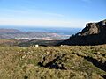
Overview of Irun, Hondarribia and a tip of Hendaia
-
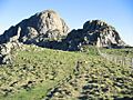
The trail northwards on Aiako Harria
-
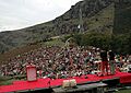
Meeting held in Aritxulegi on the Gudari Eguna 2006


See also
 In Spanish: Peñas de Aya para niños
