Pelorus Islet facts for kids

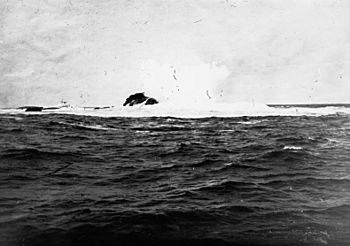
Pelorus Rocks, off Kangaroo Island, ca 1925
|
|
| Lua error in Module:Location_map at line 420: attempt to index field 'wikibase' (a nil value). | |
| Geography | |
|---|---|
| Location | Great Australian Bight |
| Administration | |
|
Australia
|
|
| Demographics | |
| Population | 0 |
Pelorus Islet is a small piece of land, or islet, in South Australia. It is also known as Pelorus Reef or Pelorus Rock. You can find it in the Great Australian Bight, which is a large bay off the south coast of Kangaroo Island. The islet is about 7 kilometers (4.3 miles) east-southeast of Cape Gantheaume. Captain Francis Harding of the Royal Navy named it after his ship, HMS Pelorus.
Contents
What is Pelorus Islet Like?
Pelorus Islet is located about 7 kilometers (4.3 miles) east-southeast of Cape Gantheaume. It is actually made up of three separate small islands or rocks. The main part is a round-topped peak that stands about 12 meters (39 feet) high. To its east, there is a reef with several rocks that stick out of the water. Another exposed rock can be seen to its southwest. It is very hard to reach Pelorus Islet by boat. This is because the area always has strong ocean swells.
How Pelorus Islet Formed
Pelorus Islet was created a very long time ago, between 7,500 and 8,900 years ago. This happened when sea levels rose at the start of the Holocene period. The Holocene is the current geological age, which began after the last ice age. When the sea levels rose, Kangaroo Island became separated from the Yorke Peninsula and Fleurieu Peninsula.
Pelorus Islet is what is left of a volcanic intrusion. This means it was formed when hot, melted rock pushed up from deep inside the Earth. Scientists believe this rock is about 506 million years old. The islet rises very steeply from the ocean floor, which is about 35 meters (115 feet) deep around it.
Plants and Animals on the Islet
In 1996, scientists observed that there were no plants growing on Pelorus Islet. The islet has been "scoured" by the ocean, meaning strong waves and weather have washed away all the soil and small rocks. Only a few large boulders remain.
The only animals with backbones (vertebrates) that have been seen on the islet are New Zealand fur seals. These seals often rest on the rocks. Greater crested terns, which are a type of seabird, have also been observed there.
A Brief History of Pelorus Islet
The French explorer Nicolas Baudin was likely the first European to describe Pelorus Islet. However, he did not give it a name. The islet was later surveyed in May 1838 by a British ship called HMS Pelorus. This ship was commanded by Captain Francis Harding. It is believed that Captain Harding named the islet after his ship.
Pelorus Islet is also known as the site of a shipwreck. On June 14, 1890, a large steamship named You Yangs was wrecked there. The You Yangs was a 672-ton ship owned by Howard Smith and Sons.
Protecting Pelorus Islet
Pelorus Islet has special protection status. This means it is a protected area to help conserve its natural environment. It first became a fauna reserve under a law called the Fauna Conservation Act 1964. A fauna reserve is a place where animals are protected.
Later, in 1967, it became a fauna conservation reserve under the Crown Lands Act 1929-1966. As of 2016, Pelorus Islet is part of the Cape Gantheaume Conservation Park. This park helps protect the land and its wildlife.
The waters around Pelorus Islet are also protected. Since 2012, these waters are part of a habitat protection zone. This zone is located within the Southern Kangaroo Island Marine Park. A habitat protection zone helps keep the ocean environment safe for marine life.
 | Shirley Ann Jackson |
 | Garett Morgan |
 | J. Ernest Wilkins Jr. |
 | Elijah McCoy |

