Peshastin, Washington facts for kids
Quick facts for kids
Peshastin, Washington
|
|
|---|---|

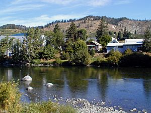
Peshastin from the Wenatchee River
|
|
| Country | United States |
| State | Washington |
| County | Chelan |
| Elevation | 1,034 ft (315 m) |
| Time zone | UTC-8 (Pacific (PST)) |
| • Summer (DST) | UTC-7 (PDT) |
| ZIP code |
98847
|
| Area code(s) | 509 |
| GNIS feature ID | 1524346 |
Peshastin is a small community located in Chelan County, Washington, United States. It is called an "unincorporated community" because it doesn't have its own local government like a city or town.
The history of Peshastin began with an important project called the "Peshastin Ditch." Pioneers started digging this ditch in 1889. It was a big part of the irrigation system that brought water to the fruit orchards on the hills above Cashmere. The town itself was first planned in the early 1890s by two brothers, J. Q. Gilbert and A. C. Gilbert. Maps from 1895 show that Peshastin was already an established place by then.
Today, Peshastin is still a small, quiet community. It has an elementary school for younger students and a local library.
Where is Peshastin Located?
Peshastin is found in the beautiful valley of the Wenatchee River. If you travel upstream (against the river's flow), you'll find the community of Leavenworth. Traveling downstream (with the river's flow) leads to Dryden.
Elevation and Nearby Peaks
The valley floor where Peshastin sits is about 1,034 feet (315 meters) above sea level. On both sides of the Wenatchee River, within a mile of Peshastin, you can see mountain peaks rising to over 2,000 feet (610 meters).
Road Connections
U.S. Route 2 is a major highway that runs past Peshastin on the south side of the river. This highway connects Peshastin to Wenatchee, which is a larger regional center. Wenatchee is about 19 miles (30 kilometers) southeast by road, and it's where the Wenatchee River flows into the mighty Columbia River. About a mile southeast of Peshastin, U.S. Route 2 meets another important highway, U.S. Route 97.
See also
 In Spanish: Peshastin (Washington) para niños
 | DeHart Hubbard |
 | Wilma Rudolph |
 | Jesse Owens |
 | Jackie Joyner-Kersee |
 | Major Taylor |


