Petatlán facts for kids
Quick facts for kids
Petatlán
|
||
|---|---|---|
|
City
|
||

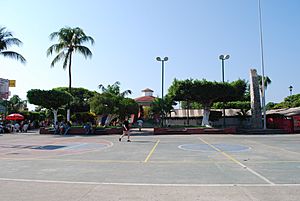
Basketball court and kiosk in city center
|
||
|
||
| Country | ||
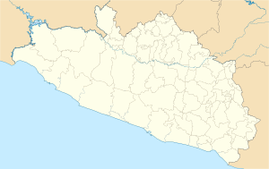
| State | Guerrero | |
| Municipality | Petatlán | |
| Founded | 1550 | |
| Municipal Status | 1870 | |
| Area | ||
| • Total | 2,071.7 km2 (799.9 sq mi) | |
| Elevation
(of seat)
|
57 m (187 ft) | |
| Population
(2005) Municipality
|
||
| • Total | 44,485 | |
| • Seat | 20,720 | |
| Time zone | UTC-6 (Zona Centro) | |
| Postal code (of seat) |
40850
|
|
Petatlán is a city on the Pacific Coast of Mexico. It is located in the state of Guerrero. The city is part of the Costa Grande region. This area is found between the cities of Zihuatanejo and Acapulco. Petatlán is famous for its Sanctuary of the Padre Jesús. This church holds a special 17th-century image of Christ. Many people believe this image has performed miracles. The city is also the main town of a large area called the Petatlán Municipality. This area touches the Pacific Ocean to the south. It is also bordered by the Sierra Madre del Sur mountains to the north. The area is home to the La Soledad de Maciel archeological site. This is an important place where ancient ruins are found.
Contents
About Petatlán City
The city of Petatlán is located just off Federal Highway 200. This highway is east of the popular tourist city of Zihuatanejo. In 2005, about 21,000 people lived in Petatlán.
City Center and Local Life
The center of Petatlán has a traditional main plaza. This plaza is surrounded by pretty gardens. It also has a basketball court where people can play. Around this main plaza, you will find the Casa de Cultura. This is a cultural center for the community. The municipal palace, which is like the city hall, is also nearby. Petatlán is well-known for its markets and shops. These places sell gold and items made from gold. A special local food is tamales. These tamales are made with goat meat and wrapped in banana leaves.
The Padre Jesús de Petatlán Sanctuary
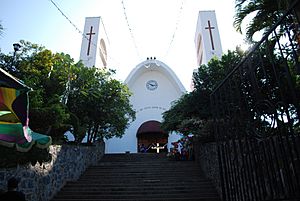
The city is most famous for the Padre Jesús de Petatlán Sanctuary. This sanctuary is a large, white church with very big wooden doors. Its official name is Santuario Nacional del Santo Señor de Petatlán. Inside, there is an image of Christ. It shows him falling while carrying the Cross. This image was made in the 17th century. Many people believe this image has caused many miracles. Devoted followers lovingly call it "Tata Chuy" or "Papa Chuy." "Tata" means grandfather, and "Papa" means dad. "Chuy" is a common nickname for Jesús.
Just outside the church's atrium, you will find vendors. They sell gold items and religious souvenirs. The sanctuary is a very important place for pilgrimages in the region. Many people visit it, especially during Holy Week. During this week, as many as 30,000 people come to the city.
Holy Week Celebrations
During Holy Week, Petatlán holds a fair called Fexpo. However, the most important event of the week is a Passion Play. In this play, about 60 local people are chosen to act out the story of Jesus. They play Jesus and other main characters. The play starts at the sanctuary. Then, it follows a five-kilometer path. Along this path, they act out the Stations of the Cross. The play ends on a hill in the Colonia Benito Juarez neighborhood. This hill is meant to look like Calvary.
History of Petatlán
The name Petatlán comes from two words in the Nahuatl language. "petatl" means "straw mat." "tlan" means "next to." So, Petatlán means "next to the straw mat."
Early Inhabitants
By the 11th century, three main groups of people lived in the Petatlán area. These were the Cuitlatecos, the Chumbias, and the Pantecas. The first time the Aztecs came to the Costa Grande region was in 1497. In 1504, the Aztec ruler Moctezuma Xocoyotzin created a special area called Cihuatlán. This area included Petatlán. People living there had to pay tribute to the Aztecs.
Spanish Arrival and Founding
After the Spanish conquest of the Aztec Empire, Petatlán became part of a land grant. This grant was given to a Spanish leader named Ginés de Pinzón. A religious group called the Augustinians began to teach Christianity here. Friar Juan Bautista Moya was one of them. This friar brought the scattered people together. He helped found the modern town of Petatlán in 1550. Later, in 1786, this town became part of the Zacatuna area.
Petatlán in Independent Mexico
During the Mexican War of Independence, Petatlán was made part of the Tecpan province. This province was created by José María Morelos y Pavón in 1811. When Agustín de Iturbide was in power, Petatlán became part of the Capitanía General del Sur. When Mexico became a republic, Petatlán was part of the Acapulco district. This district was in the State of Mexico. Later, when Guerrero became its own state, Petatlán joined the district of Galeana.
Petatlán became an independent municipality for the first time in 1870. It combined land from the municipality of De la Union and some communities from Tecpan. It was independent for a short time in 1871, then it was made a municipality again. In 1913, the town was attacked by Zapatista forces. In 1953, some of its western land was used to create the José Azueta (Zihuatanejo) municipality.
See also
 In Spanish: Petatlán para niños
 | Jewel Prestage |
 | Ella Baker |
 | Fannie Lou Hamer |


