Petersham (CDP), Massachusetts facts for kids
Quick facts for kids
Petersham, Massachusetts
|
|
|---|---|

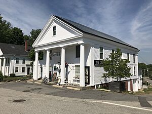
The Country Store
|
|
| Country | |
| State | Massachusetts |
| County | Worcester |
| Town | Petersham |
| Area | |
| • Total | 1.23 sq mi (3.20 km2) |
| • Land | 1.23 sq mi (3.20 km2) |
| • Water | 0.00 sq mi (0.00 km2) |
| Elevation | 1,096 ft (334 m) |
| Population
(2020)
|
|
| • Total | 225 |
| • Density | 182.33/sq mi (70.42/km2) |
| Time zone | UTC-5 (Eastern (EST)) |
| • Summer (DST) | UTC-4 (EDT) |
| ZIP Code |
01366
|
| Area code(s) | 351/978 |
| FIPS code | 25-53085 |
| GNIS feature ID | 2630529 |
Petersham is a small village in Worcester County, Massachusetts, United States. It is known as a census-designated place (CDP). This means it is a special area that the government counts separately for population information.
The village is part of the larger town of Petersham. It is a quiet place with a rich history.
Exploring Petersham Village
Petersham village is easy to find because two main roads pass through it. These roads help people travel to and from the village.
Roads and Travel
Massachusetts Route 32 goes right through the center of Petersham. If you go north on Route 32, you will reach Athol in about 9 miles. If you head southeast, you will get to Barre in about 7 miles.
Another important road, Massachusetts Route 122, also meets Route 32 in the village. Route 122 goes southeast with Route 32 towards Barre. But if you go northwest on Route 122, you will arrive in Orange after about 11 miles.
People and Numbers
The government counts how many people live in different areas every ten years. This is called a census.
- In 2010, the Petersham village area (the CDP) had 243 people living there.
- The entire town of Petersham had a larger population of 1,234 people in 2010.
- By 2020, the population of the Petersham village area was 225 people.
This shows that the village is a small community within the larger town.
See also
- Petersham (condado de Worcester) para niños (in Spanish)


