
Pic de Sanfonts facts for kids
Quick facts for kids Pic de Sanfonts |
|
|---|---|

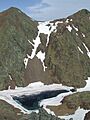
Pic de Sanfonts (left), Agulla de Baiau (right) and Estany Negre.
|
|
| Highest point | |
| Elevation | 2,894 m (9,495 ft) |
| Prominence | 150 m (490 ft) |
| Geography | |

Pic de Sanfonts
Location in Pyrenees
|
|
| Location | Andorra |
| Parent range | Pyrenees |
Pic de Sanfonts is a tall mountain located in the Pyrenees mountain range. It sits right on the border between Spain and the small country of Andorra.
This mountain is very close to Arinsal, a town in Andorra. It is also a smaller peak near Coma Pedrosa, which is the highest mountain in Andorra. Pic de Sanfonts is about 1.2 kilometers southwest of Coma Pedrosa.
What is Pic de Sanfonts?
Pic de Sanfonts is a mountain peak that reaches a height of 2,894 meters (about 9,495 feet) above sea level. Mountains like this are formed over millions of years by the movement of the Earth's crust. They are often part of larger mountain ranges.
Where is it located?
Pic de Sanfonts is found in the Pyrenees, a large mountain range that separates the Iberian Peninsula from the rest of Europe. This mountain specifically marks a part of the border between Spain and Andorra. Andorra is a tiny country known for its mountains and valleys.
How high is it?
The peak of Pic de Sanfonts stands at 2,894 meters. This makes it one of the many high peaks in the Pyrenees. It is also considered a "two-thousander" because its height is over 2,000 meters. Climbing mountains like Pic de Sanfonts can be a challenging adventure for experienced hikers.
Images for kids
-
Pic de Sanfonts (left), Agulla de Baiau (right) and Estany Negre.
See also

- In Spanish: Pico de Sanfonts para niños
