
Pickrelltown, Ohio facts for kids
Quick facts for kids
Pickrelltown, Ohio
|
|
|---|---|

Aerial view of Pickrelltown from the east
|
|

Location of Pickrelltown, Ohio
|
|
| Country | United States |
| State | Ohio |
| County | Logan |
| Township | Monroe |
| Elevation | 1,414 ft (431 m) |
| Time zone | UTC-5 (Eastern (EST)) |
| • Summer (DST) | UTC-4 (EDT) |
| GNIS feature ID | 1061538 |
Pickrelltown is a small, unincorporated community in Logan County, Ohio. This means it's a group of homes and businesses that isn't officially a town or city with its own local government. It is located in northern Monroe Township, right where two county roads, 28 and 29, meet.
People have also called Pickrelltown by other names. These include "Frogtown," "Pickereltown," "Pickeretown," and "Pickreltown."
Contents
History of Pickrelltown
Pickrelltown got its first post office in 1851. This office helped people send and receive mail until 1903. The community was named after Henry Pickerel. He owned a "tanyard" here, which was a place where animal hides were turned into leather.
Geography and Surroundings
Pickrelltown is located a short distance south of the Mad River Mountain Ski Resort. It is also southeast of the city of Bellefontaine.
The area around Pickrelltown is where the Macochee Creek begins. This is a small stream that eventually flows into the Mad River. The Macochee Creek meets the Mad River near West Liberty.
Historically, a town called Pigeon Town was located nearby. This was a town of the Shawnee people, specifically their Mekoche division. It was situated on the Mad River, about 3 miles northwest of West Liberty, Ohio.
Notable People from Pickrelltown
One important person from Pickrelltown was Solomon L. Hoge. He was a justice on the South Carolina Supreme Court. He also served as a U.S. representative for South Carolina. This means he was a lawmaker who helped make decisions for the country.
Images for kids
-
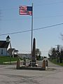
World War I veterans memorial in Pickrelltown (2010 photo). The 8 ft (2.4 m) high granite monument was erected in 1921, and has twice been rebuilt after vehicles crashed into it.
-
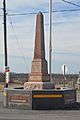
Rebuilt veterans memorial following its destruction in 2014.
-
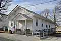
Monroe Township hall at Pickrelltown.
-
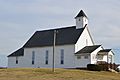
Monroe Community Church at Pickrelltown.


