Pico del Caballo facts for kids
Quick facts for kids Pico del Caballo |
|
|---|---|

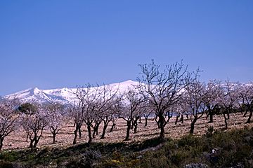
View of the Pico del Caballo behind almond trees
|
|
| Highest point | |
| Elevation | 3,011 m (9,879 ft) |
| Listing | Mountains of Spain |
| Geography | |
| Country | Spain |
| Parent range | Penibaetic System |
| Geology | |
| Mountain type | Mica-Schist |
| Climbing | |
| First ascent | Unknown |
| Easiest route | From Nigüelas or Lanjarón |
Pico del Caballo, also known as Cerro del Caballo, is a tall mountain in Spain. Its name means "horse peak." It stands 3,011-metre (9,879 ft) high in the Sierra Nevada mountain range. This mountain is special because it's the most western peak in the range that is over 3,000 meters (about 9,842 feet) tall. It's a popular spot for hikers and offers amazing views.
Contents
Climbing Pico del Caballo
You can reach Pico del Caballo from a few different places. Popular starting points include the towns of Lanjarón and Durcal. You can also begin your climb from the Sierra Nevada Ski Station. This ski resort is located at Pradollano, near Pico de Veleta.
Mountain Huts and Shelters
There is a small hut on the east side of Pico del Caballo. It sits at an altitude of 2,800 meters (about 9,186 feet). This hut can fit about eight people. It is open all year round. This type of hut is called a "bivouac." It means it's a basic shelter meant only for protection. It doesn't offer meals or heating like some larger, "guarded" huts.
The closest water source is the Río Lanjarón. This river is on the south side of Pico del Caballo. There are also small seasonal rivers on the west side of the mountain. These are at an altitude of 2,500 meters (about 8,200 feet). Sometimes, these smaller rivers can be hard to find.
Winter Climbing Conditions
During winter, the Sierra Nevada mountains get very cold. They have conditions similar to the Alps. Even though there are not many glaciers left, it's still important to be prepared. If you climb in winter, you will need special gear. This includes ice-axes and crampons. These tools help you walk safely on ice and hard snow.
Exploring Around the Mountain
Pico del Caballo offers amazing views of nearby mountains. You can see famous peaks like Veleta, Mulhacén, and Alcazaba. A long ridge starts from Caballo. It continues for several kilometers at a similar height. This ridge turns at the Tajos de la Virgen mountain, which is 3,237 meters (about 10,620 feet) tall.
Popular Hiking Routes
This ridge has become very popular for hikers. During the summer, it offers an easy walk and some fun scrambling. From Tajos de la Virgen, the ridge turns towards the southwest. It then ends on the south side of Caballo mountain. This creates a shape like a big letter "Y." The highest point on the southern ridge is Tajo de los Machos. It stands at 3,088 meters (about 10,131 feet).
Rivers and Lakes
The Río Lanjarón starts in the middle of these two ridges. It begins about 400 meters (about 1,312 feet) lower than the peaks. The river flows for several kilometers down towards the town of Lanjarón. There are also a few lakes in this wide mountain valley. They add to the beautiful scenery around Pico del Caballo.
See also
 In Spanish: Pico del Caballo para niños


