
Picture Butte facts for kids
Quick facts for kids
Picture Butte
|
|
|---|---|
|
Town
|
|
| Town of Picture Butte | |
| Nickname(s):
Livestock Feeding Capital of Canada
|
|

Picture Butte
Location in Alberta
|
|
| Country | Canada |
| Province | Alberta |
| Region | Southern Alberta |
| Census division | 2 |
| Municipal district | Lethbridge County |
| Incorporated | |
| • Village | February 4, 1943 |
| • Town | January 1, 1960 |
| Area
(2021)
|
|
| • Land | 3.02 km2 (1.17 sq mi) |
| Elevation | 905 m (2,969 ft) |
| Population
(2021)
|
|
| • Total | 1,930 |
| • Density | 639.7/km2 (1,657/sq mi) |
| Time zone | UTC−7 (MST) |
| • Summer (DST) | UTC−6 (MDT) |
| Postal code span |
T0K 1V0
|
| Highways | Highway 25 Highway 519 |
| Waterway | Oldman River |
Picture Butte is a friendly town in southern Alberta, Canada. It's located about 27 kilometers (17 miles) north of the city of Lethbridge. This town is famous for being the "Livestock Feeding Capital of Canada."
Contents
What's in a Name? The Story of Picture Butte
The name "Picture Butte" comes from the Blackfoot people's language. In 2010, researchers Ernest and Austin Mardon explained that it means "the beautiful hill."
This name came from a small hill southeast of the town. Sadly, this hill no longer exists. Its soil was used for building roads and a dyke near the Picture Butte Lake Reservoir by 1947.
A Look Back: Picture Butte's History
People started settling in the Picture Butte area in the early 1900s. The town grew quickly after two big projects were finished.
The Lethbridge Northern Irrigation System was built in 1923. This system brought water to farms. Then, the CPR built a train line in 1925. These projects brought many new settlers to the area. The first post office opened in 1925.
Picture Butte officially became a village in 1943. By 1961, its population grew to 978 people, and it became a town.
In 1978, the Canadian Sugar Factory closed down. This meant fewer jobs and less money for the town. Today, Picture Butte has smaller businesses. These include service companies, warehouses, and wholesale stores.
The town's size changed in 1991 when it added about 165 acres (0.67 square kilometers) of land.
Farms in the Picture Butte area often change and adapt. For example, in 2016, Scholten Farms changed from raising pigs to raising cattle. This shows how local businesses keep up with new needs.
Who Lives Here? Picture Butte's Population
|
|||||||||||||||||||||||||||||||||||||||||||||
In 2021, Statistics Canada counted 1,930 people living in Picture Butte. They lived in 689 homes. This was a small increase from 1,810 people in 2016.
The town covers an area of 3.02 square kilometers (1.17 square miles). This means there were about 639.7 people per square kilometer in 2021.
In 2016, the town had 1,810 people living in 672 homes. This was an increase from 1,650 people in 2011. The town's land area was 2.85 square kilometers (1.10 square miles) at that time.
Fun Things to Do: Attractions in Picture Butte
Picture Butte has many places for people to visit and enjoy. As of 2023, you can find an art gallery and three schools. There are also three churches and a sports complex.
The town has a community league, a museum, and a historical village. These places help people learn about the town's past and have fun.
How Picture Butte is Governed

Picture Butte is run by a group of elected officials. They make decisions for the town.
Who Are Picture Butte's Mayors?
Here is a list of people who have served as mayor of Picture Butte:
- John Maurice Gibbons
- Heber Jones
- Harry Watson
- Sydney P. Johnson
- Wilfrid Hague
- Victor Edward (Ted) Crapnell
- Morgan W. Heninger
- Rick Casson
- Bert Foord
- Alex Chronik
- Elton Anderson
- Jon Stevens
- Terry Kerkhoff
- Wendy Jones
- Cathy Moore
Meet the Current Town Council
The people on the Picture Butte town council were chosen in the 2021 Alberta municipal elections. As of 2023, the mayor is Cathy Moore. The councilors are Henry deKok, Teresa Feist, Cynthia Papworth, and Crystal Neels. They work together to lead the town.
Gallery
- Photographs of Picture Butte
-
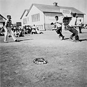
Baseball game at Picture Butte School
-
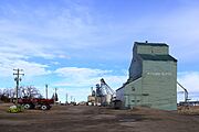
Picture Butte grain elevator
-
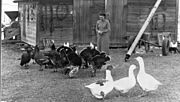
Chicken farm in Picture Butte
-
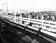
Cattle feedlot in picture butte
.jpg)
.jpg)
.jpg)
.jpg)
Famous People from Picture Butte
Some well-known people have come from Picture Butte:
- Alex Brown Johnston, a politician
- Rick Casson, also a politician
