Lethbridge County facts for kids
Quick facts for kids
Lethbridge County
|
||
|---|---|---|
|
||

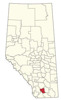
Location within Alberta
|
||
| Country | Canada | |
| Province | Alberta | |
| Region | Southern Alberta | |
| Census division | 2 | |
| Incorporated | January 1, 1954 | |
| Name changes | January 1, 1964 September 6, 2000 December 4, 2013 |
|
| Area
(2021)
|
||
| • Land | 2,815.66 km2 (1,087.13 sq mi) | |
| Population
(2021)
|
||
| • Total | 10,120 | |
| • Density | 3.6/km2 (9/sq mi) | |
| Time zone | UTC−7 (MST) | |
| • Summer (DST) | UTC−6 (MDT) | |
Lethbridge County is a special kind of local government area in southern Alberta, Canada. It's like a big neighbourhood that includes many smaller towns and villages. This area is part of a larger region called Census Division No. 2. It also connects to the city of Lethbridge as part of its wider urban area.
Before December 4, 2013, this place was known as the County of Lethbridge. Its name was changed to Lethbridge County just in time for its 50th birthday in 2014.
Contents
History of Lethbridge County
Lethbridge County covers an area that used to be managed by six different local governments. It was first created on January 1, 1954. This happened when two areas, Bright No. 16 and Barons No. 25, joined together. Parts of other areas like Special Area No. 4, Vulcan County, Warner No. 4, and Sugar City No. 5 also became part of it.
Ten years later, on January 1, 1964, the Municipal District of Lethbridge No. 25 combined with the Lethbridge School Division No. 7. This new, larger area was called the County of Lethbridge No. 26. The name changed again on September 6, 2000, to simply the County of Lethbridge. Finally, on December 4, 2013, it became what we know today as Lethbridge County.
Geography and Communities
Lethbridge County is home to many different places, from big cities to small villages and hamlets. These communities are important parts of the county's geography.
Urban Areas in Lethbridge County
|
The following urban areas are surrounded by Lethbridge County:
|
The following hamlets are located within Lethbridge County:
|
Localities in Lethbridge County
Localities are smaller places that might not be towns or villages but are still recognized areas within the county.
- Localities
|
|
Population and Demographics
Every few years, Statistics Canada counts how many people live in different areas. This is called a census. It helps us understand how communities are growing or changing.
In the 2021 Census, Lethbridge County had 10,120 people living there. These people lived in 2,890 homes. This was a small change of -1.1% from its population in 2016, which was 10,237 people.
The county covers a land area of about 2,815.66 square kilometers. This means that in 2021, there were about 3.6/km2 (9.3/sq mi) people for every square kilometer. This number is called the population density.
In the 2016 Census, Lethbridge County had 10,353 people. This was a 3.1% change from its 2011 population of 10,046.
Economy and Industries
The main way people in Lethbridge County make a living is through farming. This includes growing crops and raising animals.
One very important area is known as "Feedlot Alley". This is a large area, about 500 square kilometers, where many livestock (like cattle) are raised in a very organized way. This type of farming is called intensive farming because it focuses on producing a lot of food from a smaller area.
 | Calvin Brent |
 | Walter T. Bailey |
 | Martha Cassell Thompson |
 | Alberta Jeannette Cassell |


