Pinconning River facts for kids
Quick facts for kids Pinconning River |
|
|---|---|

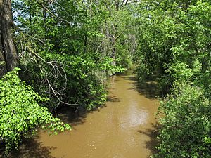
The Pinconning River in Pinconning Township
|
|

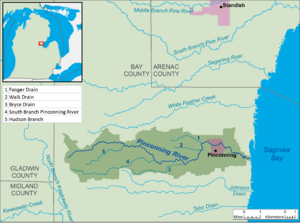
A map of the Pinconning River and its watershed.
|
|
| Native name | Opinikaakiing-ziibi |
| Country | United States |
| State | Michigan |
| County | Bay |
| Townships | Mount Forest, Pinconning |
| Municipality | Pinconning |
| Physical characteristics | |
| Main source | Mount Forest Township 679 ft (207 m) 43°50′54″N 84°08′59″W / 43.8483564°N 84.1497153°W |
| River mouth | Saginaw Bay Pinconning Township 577 ft (176 m) 43°50′49″N 83°55′15″W / 43.8469655°N 83.9208187°W |
| Length | 10.9 mi (17.5 km) |
| Basin features | |
| Basin size | 26.6 sq mi (69 km2) |
| Hydrologic Unit Code | 040801020107 (USGS) |
The Pinconning River is a small river located in the central part of Michigan in the United States. Its name comes from the Ojibwe language, Opinikaaning-ziibi, which means "River at potatoing-grounds." Sometimes, it's shortened to Pinkaaning-ziibi.
This river is about 15.6 miles (25.1 km) long. It flows into Saginaw Bay, which is part of Lake Huron. The river and all the land that drains into it, called its drainage basin or watershed, covers an area of 26.6 square miles (69 km2). Because Lake Huron is connected to the other Great Lakes and the St. Lawrence River, the Pinconning River is part of a much larger water system.
Contents
Where Does the Pinconning River Flow?
The Pinconning River and its entire watershed are found in the northern part of Bay County. The river starts in Mount Forest Township. This is about 9.4 miles (15.1 km) west of the city of Pinconning.
From its start, the river generally flows towards the east. It travels through Pinconning Township and then through the city of Pinconning itself. Finally, it empties into Saginaw Bay. This happens in Pinconning Township, about 2.2 miles (3.5 km) east of the city of Pinconning.
What Are the Main Branches of the River?
The biggest stream that flows into the Pinconning River is called the South Branch Pinconning River. This branch is 6.2 miles (10.0 km) long. It joins the main Pinconning River before the river reaches the city of Pinconning.
Protecting the Pinconning River
People are working to protect the Pinconning River and its natural areas. The Saginaw Bay Land Conservancy owns a special nature preserve along the river. This preserve is called the Pinconning Nature Preserve and is located in Pinconning Township.
There's also a county park called Pinconning Park. This park is run by Bay County and is located on the north bank of the river, right where it meets Saginaw Bay. These places help keep the river healthy and provide areas for people to enjoy nature.
Streams That Join the Pinconning River
Many smaller streams flow into the Pinconning River. These are called tributaries. Here is a list of the named streams that are part of the Pinconning River's watershed. They are listed starting from the mouth of the river (where it meets Saginaw Bay) all the way up to its source (where it begins).
| Name | Length | |
|---|---|---|
| 1 | Fanger Drain | 2.4 miles (3.9 km) |
| 2 | Walk Drain | 1.8 miles (2.9 km) |
| 3 | Bryce Drain | 4.1 miles (6.6 km) |
| 4 | South Branch Pinconning River | 6.2 miles (10.0 km) |
| 5 | Hudson Branch | 3.3 miles (5.3 km) |
 | Frances Mary Albrier |
 | Whitney Young |
 | Muhammad Ali |

