Pinhook, Missouri facts for kids
Quick facts for kids
Pinhook, Missouri
|
|
|---|---|
|
Inactive Village
|
|

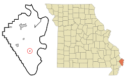
Location in Mississippi County and the state of Missouri
|
|
| Country | |
| State | |
| County | Mississippi |
| Incorporated | February 23, 1995 |
| Area | |
| • Total | 0.14 sq mi (0.37 km2) |
| • Land | 0.14 sq mi (0.37 km2) |
| • Water | 0.00 sq mi (0.00 km2) |
| Elevation | 302 ft (92 m) |
| Population
(2020)
|
|
| • Total | 6 |
| • Density | 42.25/sq mi (16.30/km2) |
| Time zone | UTC-6 (Central (CST)) |
| • Summer (DST) | UTC-5 (CDT) |
| FIPS code | 29-57926 |
| GNIS feature ID | 2399677 |
Pinhook was a small village in Mississippi County, Missouri, in the United States. It is now considered an inactive village. In 2020, only 6 people lived there. This was a big drop from 30 people in 2010.
History of Pinhook
Pinhook was first settled in the 1920s or 1930s. The first residents were sharecroppers. Sharecroppers were farmers who worked on land owned by someone else. They paid for using the land with a share of their crops.
The village got its name from a nearby ridge. This ridge was shaped like a "pinhook." A pinhook is a tool used to move logs. At its busiest time, Pinhook was home to almost 250 people. Most of the people living there were African American.
In May 2011, Pinhook faced a major flood. The U.S. Army Corps of Engineers broke open the Bird's Point Levee. A levee is a wall built to stop a river from flooding. They did this to protect the town of Cairo, Illinois from the rising water.
The people of Pinhook were left to deal with the flood on their own. The government did not help them evacuate before the levee was broken. After the flood, the former residents moved to other towns. Many went to East Prairie and Sikeston. By August 2015, all the remaining buildings in Pinhook were taken down.
Where is Pinhook?
Pinhook is located in the southern part of Mississippi County. You can find it at these coordinates: 36°44′21″N 89°16′4″W / 36.73917°N 89.26778°W.
It is about 9 miles (14 km) southeast of East Prairie. It is also about 16 miles (26 km) south of Charleston. Charleston is the main town of Mississippi County. The Mississippi River is about 6 miles (10 km) to the east. It is also about 7 miles (11 km) to the southwest.
The village area covers about 0.14 square miles (0.37 square kilometers). All of this area is land.
Population Changes in Pinhook
The number of people living in Pinhook changed a lot over the years.
| Historical population | |||
|---|---|---|---|
| Census | Pop. | %± | |
| 2000 | 48 | — | |
| 2010 | 30 | −37.5% | |
| 2020 | 6 | −80.0% | |
| U.S. Decennial Census 2010 2020 |
|||
In 2000, there were 48 people living in Pinhook. By 2010, the population had dropped to 30 people. In 2020, only 6 people remained. This shows a big decrease in the number of residents over time.
See also
 In Spanish: Pinhook (Misuri) para niños
 | Audre Lorde |
 | John Berry Meachum |
 | Ferdinand Lee Barnett |

