Pistol River facts for kids
Quick facts for kids Pistol River |
|
|---|---|

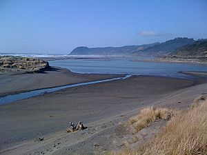
At the river mouth
|
|

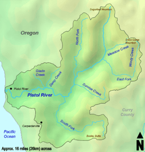
The Pistol River watershed
|
|
|
Location of the mouth of the Pistol River in Oregon
|
|
| Country | United States |
| State | Oregon |
| County | Curry |
| Physical characteristics | |
| Main source | near Sugarloaf Mountain Siskiyou National Forest, Southern Oregon Coast Range 3,179 ft (969 m) 42°24′10″N 124°12′25″W / 42.40278°N 124.20694°W |
| River mouth | Pacific Ocean Pistol River State Scenic Viewpoint, near Pistol River 7 ft (2.1 m) 42°16′46″N 124°24′27″W / 42.27944°N 124.40750°W |
| Length | 21 mi (34 km) |
| Basin features | |
| Basin size | 105.1 sq mi (272 km2) |
The Pistol River is a cool stream in Oregon that flows for about 21 miles (34 km). It starts way up in the Siskiyou National Forest and winds its way through the Southern Oregon Coast Range before reaching the big Pacific Ocean. You can find its mouth near a small community also called Pistol River.
The river got its interesting name back in 1853. A pioneer named James Mace accidentally lost his pistol in the river! That's how the name "Pistol River" came to be.
This river is super important for many fish. It's home to chinook salmon, coho salmon (which are a threatened species, meaning they need our help to survive!), steelhead, and coastal cutthroat trout. Sadly, logging in the surrounding forests has sometimes harmed the fish's homes. But don't worry, people are working hard to fix these areas and make the river a better place for fish again!
The River's Journey
The Pistol River begins its journey high up in the forest. At first, it flows south. Along the way, smaller streams join it. Meadow Creek flows into it from the left side, and then the East Fork Pistol River also joins from the left.
The river then turns southwest. The North Fork Pistol River adds its water from the right side. Sunrise Creek joins from the left, about 11 miles (18 km) before the river reaches the ocean. Next, the river turns west, heading straight for the Pacific.
Closer to the ocean, the South Fork Pistol River flows in from the left. Then, Deep Creek and Glade Creek join from the right, about 5 miles (8 km) from the mouth. Finally, Crook Creek enters from the right near the community of Pistol River. The river then flows under the Pistol River Loop Highway and a bigger road called U.S. Route 101. After that, it empties into the Pacific Ocean at the Pistol River State Scenic Viewpoint.
The River's Land Area
The Pistol River's watershed is like a giant bowl that collects all the rain and snow that eventually flows into the river. This watershed covers about 105 square miles (272 km²) in Curry County.
Most of this land, about 57 percent, is public land. This means it's managed by groups like the United States Forest Service and the Bureau of Land Management. The other 43 percent of the land is privately owned.
What do people do with this land? Well, about 97 percent of the watershed is used for forestry, which means growing and harvesting trees. The remaining small part, about 3 percent, is used for things like farming, raising animals, and homes in the countryside.
 | Kyle Baker |
 | Joseph Yoakum |
 | Laura Wheeler Waring |
 | Henry Ossawa Tanner |


