
Pitahaya, Arroyo, Puerto Rico facts for kids
Quick facts for kids
Pitahaya
|
|
|---|---|
|
Barrio
|
|

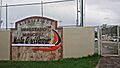
Small stadium in Pitahaya
|
|

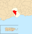
Location of Pitahaya within the municipality of Arroyo shown in red
|
|

Pitahaya, Arroyo, Puerto Rico
Location in Caribbean
|
|
| Commonwealth | |
| Municipality | |
| Area | |
| • Total | 3.19 sq mi (8.3 km2) |
| • Land | 3.19 sq mi (8.3 km2) |
| • Water | 0.00 sq mi (0 km2) |
| Elevation | 328 ft (100 m) |
| Population
(2010)
|
|
| • Total | 3,242 |
| • Density | 451.1/sq mi (174.2/km2) |
| Source: 2010 Census | |
| Time zone | UTC−4 (AST) |
Pitahaya is a special kind of neighborhood called a barrio in the town of Arroyo, Puerto Rico. It's located on the beautiful island of Puerto Rico. In 2010, about 3,242 people lived in Pitahaya.
Contents
A Look at Pitahaya's History
Pitahaya, like all of Puerto Rico, has an interesting past. Long ago, Puerto Rico was controlled by Spain. But after a war called the Spanish–American War in 1898, things changed.
Becoming Part of the United States
After the war, Spain and the United States signed a peace agreement called the Treaty of Paris of 1898. Because of this treaty, Puerto Rico became a territory of the United States. This means it's connected to the U.S. but isn't a state.
Counting the People
In 1899, the United States government did a count of all the people in Puerto Rico. This count is called a census. It helps governments understand how many people live in different areas. The census found that 801 people lived in Pitahaya barrio at that time.
Over the years, the number of people living in Pitahaya has changed. Here's how the population has grown and shrunk:
| Historical population | |||
|---|---|---|---|
| Census | Pop. | %± | |
| 1950 | 2,815 | — | |
| 1980 | 1,934 | — | |
| 1990 | 3,414 | 76.5% | |
| 2000 | 3,981 | 16.6% | |
| 2010 | 3,242 | −18.6% | |
| U.S. Decennial Census 1899 (shown as 1900) 1910-1930 1930-1950 1980-2000 2010 |
|||
Images for kids
-
Small stadium in Pitahaya
-
Location of Pitahaya within the municipality of Arroyo shown in red
Learn More
 In Spanish: Pitahaya (Arroyo) para niños
- List of communities in Puerto Rico
