
Pitahaya, Luquillo, Puerto Rico facts for kids
Quick facts for kids
Pitahaya
|
|
|---|---|
|
Barrio
|
|

Entering Casa Blaca Sector in Pitahaya
|
|

Location of Pitahaya within the municipality of Luquillo shown in red
|
|
| Lua error in Module:Location_map at line 416: Malformed coordinates value. | |
| Commonwealth | |
| Municipality | |
| Area | |
| • Total | 6.99 sq mi (18.1 km2) |
| • Land | 6.63 sq mi (17.2 km2) |
| • Water | 0.36 sq mi (0.9 km2) |
| Elevation | 230 ft (70 m) |
| Population
(2010)
|
|
| • Total | 4,523 |
| • Density | 682.2/sq mi (263.4/km2) |
| Source: 2010 Census | |
| Time zone | UTC−4 (AST) |
Pitahaya is a special place called a barrio in the town of Luquillo, Puerto Rico. Think of a barrio like a neighborhood or a district within a bigger town. In 2010, about 4,523 people lived in Pitahaya. It's located in the beautiful Commonwealth of Puerto Rico.
A Look at Pitahaya's Past
Pitahaya has an interesting history. After the Spanish–American War, Spain gave Puerto Rico to the United States. This happened because of a special agreement called the Treaty of Paris of 1898. Puerto Rico then became a territory of the U.S.
In 1899, the United States Department of War counted all the people in Puerto Rico. This count is called a census. They found that 1,103 people lived in Pitahaya barrio at that time. Over the years, more people have moved to Pitahaya.
| Historical population | |||
|---|---|---|---|
| Census | Pop. | %± | |
| 1900 | 1,103 | — | |
| 1980 | 3,216 | — | |
| 1990 | 4,002 | 24.4% | |
| 2000 | 4,505 | 12.6% | |
| 2010 | 4,523 | 0.4% | |
| U.S. Decennial Census 1899 (shown as 1900) 1910-1930 1930-1950 1980-2000 2010 |
|||
Exploring Pitahaya's Nature
One important natural feature in Pitahaya is the Pitahaya River. This river flows right through an area called the Casa Blanca sector. Rivers are important for the environment and for the people who live nearby.
Pictures of Pitahaya
-
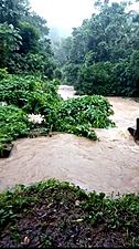
The Pitahaya River after Hurricane Isaias

See also
 In Spanish: Pitahaya (Luquillo) para niños
- List of communities in Puerto Rico
