Pitalito facts for kids
Quick facts for kids
Pitalito
|
|||
|---|---|---|---|
|
Municipality and town
|
|||

Aerial view
|
|||
|
|||

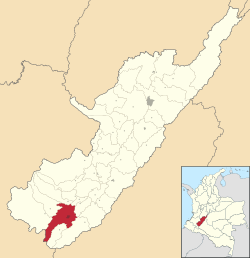
Location of the municipality and town of Pitalito in the Huila Department of Colombia.
|
|||
| Country | |||
| Department | Huila Department | ||
| Founded | June 13, 1818 | ||
| Area | |||
| • Municipality and town | 630.7 km2 (243.5 sq mi) | ||
| • Urban | 11.06 km2 (4.27 sq mi) | ||
| Elevation | 1,318 m (4,324 ft) | ||
| Population
(2020 est.)
|
|||
| • Municipality and town | 128,630 | ||
| • Density | 203.948/km2 (528.22/sq mi) | ||
| • Urban | 75,434 | ||
| • Urban density | 6,820.4/km2 (17,665/sq mi) | ||
| Demonym(s) | Laboyano | ||
| Time zone | UTC-5 (Colombia Standard Time) | ||
| Area code(s) | 57 + 8 | ||
| Website | Official website: http://www.pitalito-huila.gov.co/ | ||
Pitalito is a town and municipality in Colombia. It's located in the southern part of the Huila Department. The town sits in the beautiful Valley of the Rio Grande de la Magdalena. It's about 188 kilometers (117 miles) from Neiva, the capital city of Huila.
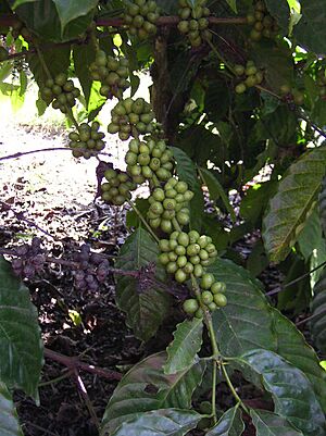
People often call Pitalito "The Valley of Laboyos." With about 128,630 people, Pitalito is the second largest town in Huila. Pitalito is famous for its coffee. It's considered the biggest coffee producer in Colombia. The town is a major coffee-growing area, especially in the District of Bruselas. Pitalito's coffee has even won the "Cup of Excellence" award several times for being the best in the country!
Pitalito shares borders with other towns. To the north are Timaná, Elias, and Saladoblanco. To the south is Palestina. To the west are Isnos and San Agustín. And to the east is Acevedo.
Contents
History of Pitalito
On December 18, 1538, a Spanish captain named Pedro de Añasco founded a village. It was in the Laboyos Valley and was first called Guacacallo. This village was important for connecting travelers and goods between Quito, Popayán, and Bogotá.
However, local tribes often attacked the village. Because of these attacks, and an event involving a leader named Cacica Gaitana, the village moved. It was relocated north, near the Timaná River, where the town of Timaná is today.
This first village was the earliest Spanish settlement in the southern Alto Magdalena region. It helped the Spanish explore new lands. They went into the territories of the Andaquíes (to the east) and the Mocoas (to the south). Later, a direct road was opened between Timaná and Pasto, through the Páramo de las Papas.
Religious centers were also set up where indigenous tribes lived. Even after the village moved, the original site remained a religious center.
In 1818, José Hilario Sierra became the Catholic priest for the "Los Laboyos" area. That year, some people from Laboyos decided to move their homes. They chose a beautiful spot called Pitalito, about two miles northeast. They liked Pitalito because the land was fertile, the climate was mild, there was plenty of water, and building materials were easy to find.
More people followed, and soon almost everyone from Laboyos moved to Pitalito. Dr. Sierra, the priest, moved with his community. He built a small chapel where he could hold Holy Mass and administer Holy Sacraments. This first chapel is still there today, at the same spot as the Temple of San Antonio. In 1819, Dr. Sierra marked out the town square and streets in front of the chapel.
After three years, the new village was growing. It needed a mayor. Don Jorge de Cuéllar was chosen for the job. His father, Don Luis de Cuéllar, was an important person from Timaná. Don Luis owned land in the region and came from a noble family in Andalusia, Spain.
Pitalito's Coffee
Colombia is the third largest producer of coffee in the world. It's also the biggest producer of washed and Arabica coffee. Colombian coffee is known for its high quality. About half of Colombia's coffee exports go to the United States. Each year, Colombia exports about 12.5 million bags of coffee.
Colombia only grows Arabica coffee, mostly using the "washed" method. There are three main types of coffee plants grown here. Coffee is often named after the region where it grows. Pitalito is a key area for washed Arabica coffee. It's located in southern Huila, in the Valley of Laboyos. This southern part of Colombia is at the base of the Andes mountains. The Magdalena River, which flows north to the Caribbean, starts in these mountains.
The valley itself is about 1,300 meters (4,265 feet) above sea level. Coffee grows on all the surrounding mountains. Most farms are about 6 hectares (15 acres) in size. They have around 5,000 coffee trees per hectare. The soil is volcanic, which means it has many natural nutrients for the coffee plants. This helps the coffee grow well at high altitudes.
What Makes Pitalito Coffee Special?
Pitalito coffee is known for its unique taste.
- Acidity: It has a high citric acidity, which gives it a bright, fresh taste.
- Body: It has a medium to good body, meaning it feels smooth and full in your mouth.
- Flavor: You might notice notes of stone fruit and caramel.
- Aroma: It often smells like caramel.
- Varieties: The main types of Arabica coffee grown here are Caturra and Castillo.
- Harvest Time: Coffee is harvested from October to February.
Tourism in Pitalito
The San Agustin Archaeological Park is a famous place located about 30 miles (48 kilometers) from Pitalito. This park was named a UNESCO World Heritage Site in 1995. It has the largest collection of religious monuments and huge stone sculptures in Latin America. It's also considered the world's biggest ancient burial ground. Pitalito has the closest airport to San Agustín, with flights to Bogota and Cali through the airline SATENA.
Hotels in Pitalito
Pitalito has many places to stay. Some popular hotels include:
- Hotel Grand Premium Plaza
- Hotel Napoles
- Hotel Hostal Ullumbe
- Hotel Calamo
- Hotel Interescorial
- Hotel Guaitipan Plaza
Restaurants in Pitalito
You can find a variety of restaurants in Pitalito. Here are a few:
- Food and Liquor Pitalito
- Arte Burger - Pitalito (Burger restaurant)
- Pizza Pitalito
- Archopi (Burger restaurant)
- Pure Love (Bar)
- La Casa en el Aire (Bar & Grill)
- Le Bistro 450 (Restaurant)
- Restaurante El Caporal
- Salu (Restaurant/Cafe)
- Sufy (Ice cream & restaurant)
Climate
| Climate data for Pitalito (Sevilla), elevation 1,320 m (4,330 ft), (1981–2010) | |||||||||||||
|---|---|---|---|---|---|---|---|---|---|---|---|---|---|
| Month | Jan | Feb | Mar | Apr | May | Jun | Jul | Aug | Sep | Oct | Nov | Dec | Year |
| Mean daily maximum °C (°F) | 27.1 (80.8) |
27.1 (80.8) |
26.7 (80.1) |
26.6 (79.9) |
26.2 (79.2) |
25.5 (77.9) |
24.7 (76.5) |
25.3 (77.5) |
26.2 (79.2) |
26.6 (79.9) |
26.5 (79.7) |
26.7 (80.1) |
26.3 (79.3) |
| Daily mean °C (°F) | 21.0 (69.8) |
21.1 (70.0) |
20.8 (69.4) |
20.7 (69.3) |
20.5 (68.9) |
19.9 (67.8) |
19.4 (66.9) |
19.5 (67.1) |
20.1 (68.2) |
20.5 (68.9) |
20.6 (69.1) |
20.8 (69.4) |
20.4 (68.7) |
| Mean daily minimum °C (°F) | 15.4 (59.7) |
15.6 (60.1) |
15.8 (60.4) |
16.0 (60.8) |
15.9 (60.6) |
15.5 (59.9) |
14.9 (58.8) |
14.8 (58.6) |
14.8 (58.6) |
15.4 (59.7) |
15.8 (60.4) |
15.7 (60.3) |
15.5 (59.9) |
| Average precipitation mm (inches) | 61.7 (2.43) |
83.9 (3.30) |
107.3 (4.22) |
135.9 (5.35) |
138.4 (5.45) |
133.5 (5.26) |
123.9 (4.88) |
98.6 (3.88) |
77.0 (3.03) |
99.6 (3.92) |
95.8 (3.77) |
80.7 (3.18) |
1,223 (48.1) |
| Average precipitation days | 12 | 14 | 18 | 20 | 22 | 21 | 22 | 20 | 18 | 17 | 18 | 16 | 215 |
| Average relative humidity (%) | 80 | 80 | 81 | 82 | 82 | 84 | 84 | 83 | 82 | 81 | 82 | 81 | 82 |
| Mean monthly sunshine hours | 148.8 | 115.7 | 99.2 | 105.0 | 120.9 | 114.0 | 114.7 | 120.9 | 126.0 | 130.2 | 129.0 | 145.7 | 1,470.1 |
| Mean daily sunshine hours | 4.8 | 4.1 | 3.2 | 3.5 | 3.9 | 3.8 | 3.7 | 3.9 | 4.2 | 4.2 | 4.3 | 4.7 | 4.0 |
| Source: Instituto de Hidrologia Meteorologia y Estudios Ambientales | |||||||||||||
See also
 In Spanish: Pitalito para niños
 | James Van Der Zee |
 | Alma Thomas |
 | Ellis Wilson |
 | Margaret Taylor-Burroughs |


