Plainfield (CDP), Vermont facts for kids
Quick facts for kids
Plainfield, Vermont
|
|
|---|---|

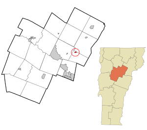
Location in Washington County and the state of Vermont
|
|
| Country | United States |
| State | Vermont |
| County | Washington |
| Area | |
| • Total | 0.23 sq mi (0.60 km2) |
| • Land | 0.23 sq mi (0.59 km2) |
| • Water | 0.004 sq mi (0.01 km2) |
| Elevation | 755.2 ft (230.2 m) |
| Population | |
| • Total | 401 |
| • Density | 1,731/sq mi (668/km2) |
| Time zone | UTC-5 (Eastern (EST)) |
| • Summer (DST) | UTC-4 (EDT) |
| ZIP code |
05667
|
| Area code(s) | 802 |
| FIPS code | 50-55750 |
Plainfield is a small village in Washington County, Vermont, in the United States. It is officially known as a "census-designated place" (CDP). This means it's a specific area that the government counts for population statistics.
In 2010, about 401 people lived in Plainfield. It's a part of the larger town of Plainfield in Vermont.
Where is Plainfield Located?
Plainfield is in the northern part of the town of Plainfield. It sits right along U.S. Route 2, which is a main road.
The village is about 10 miles (16 km) east of Montpelier. Montpelier is the capital city of Vermont. Plainfield is also about 28 miles (45 km) west of St. Johnsbury.
Plainfield is located next to the Winooski River. This river flows through much of Vermont.
Land and Water Area
The Plainfield census-designated place covers a total area of about 0.60 square kilometers (0.23 square miles). Most of this area is land. Only a very small part, about 0.01 square kilometers (0.004 square miles), is water.
Nearby Places of Interest
Just west of Plainfield village, you'll find Goddard College. This is a private college known for its unique learning programs.
See also
 In Spanish: Plainfield (condado de Washington) para niños
 | Dorothy Vaughan |
 | Charles Henry Turner |
 | Hildrus Poindexter |
 | Henry Cecil McBay |

