Plainfield Township, Kent County, Michigan facts for kids
Quick facts for kids
Plainfield Township, Michigan
|
|
|---|---|
|
Charter township
|
|
| Plainfield Charter Township | |

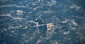
Aerial photograph of Plainfield Township in 2009
|
|

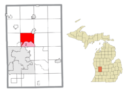
Location within Kent County (red) and administered portions of the Comstock Park (1) and Northview (2) CDPs (pink)
|
|
| Country | United States |
| State | Michigan |
| County | Kent |
| Established | 1838 |
| Area | |
| • Total | 36.73 sq mi (95.13 km2) |
| • Land | 35.04 sq mi (90.75 km2) |
| • Water | 1.69 sq mi (4.38 km2) |
| Elevation | 663 ft (202 m) |
| Population
(2020)
|
|
| • Total | 33,535 |
| • Density | 913.01/sq mi (352.518/km2) |
| Time zone | UTC-5 (Eastern (EST)) |
| • Summer (DST) | UTC-4 (EDT) |
| ZIP code(s) | |
| Area code(s) | 616 |
| FIPS code | 26-081-64660 |
| GNIS feature ID | 1626912 |
Plainfield Charter Township is a special type of local government area called a charter township. It is located in Kent County, in the state of Michigan, USA. In 2020, about 33,535 people lived here.
Plainfield Township is part of the larger Grand Rapids metropolitan area. It shares a border with the city of Grand Rapids to its south.
Contents
Communities in Plainfield Township
Plainfield Township is home to several smaller communities. Some of these are unincorporated, meaning they don't have their own separate local government.
Belmont
- Belmont is an unincorporated community within the township.
- It is located north of the Grand River.
- You can find it near exit 95 off U.S. Highway 131.
- The Rogue River joins the Grand River close to Belmont.
- Belmont has its own post office with the ZIP Code 49306.
- This community was first planned out in 1874.
Chauncey
- Chauncey is another unincorporated community.
- It is mostly a historical settlement.
- Chauncey is on the eastern border of the township, where Bear Creek flows into the Grand River.
- It was also known by the names Buena Vista and Imperial Mills.
Childsdale (Historic)
- Childsdale was a small, historic unincorporated community.
- It was located where Childsdale Avenue crosses the Rogue River, near the border with Rockford.
- In the past, Childsdale had a lumber and paper mill.
- It was also a stop on the Grand Rapids and Indiana Railroad.
- The community started in 1848 around a sawmill.
- It even had its own post office starting in 1900.
Comstock Park
- Comstock Park is a census-designated place (CDP) and an unincorporated community.
- Part of it is inside Plainfield Township, on the west side of the Grand River.
- It also stretches west into Alpine Township.
Northview
- Northview is another census-designated place and unincorporated community.
- It is located within Plainfield Township.
- Northview is situated between the borders of Grand Rapids, Grand Rapids Township, Comstock Park, and Belmont.
Geography of Plainfield Township
Plainfield Township covers a total area of about 36.73 square miles (95.13 square kilometers). Most of this area, about 35.04 square miles (90.75 square kilometers), is land. The rest, about 1.69 square miles (4.38 square kilometers), is water.
Rivers and Waterways
- The Grand River flows through the southern part of the township.
- The Rogue River is a smaller river that flows south and joins the Grand River within the township.
Neighboring Areas
Plainfield Township shares its borders with several other townships and cities:
- To the west: Alpine Township
- To the north: Algoma Township and the city of Rockford
- To the east: Cannon Township
- To the southeast: Ada Township
- To the south: Grand Rapids Charter Township and the city of Grand Rapids
- To the southwest: The city of Walker
Main Roads
 US 131 is a major highway that runs north and south through the western part of the township.
 M-44 (Beltline Avenue) also runs north and south through the eastern part.
- M-44 has a connecting route that links it to Interstate 96 to the south in Grand Rapids.
Education in Plainfield Township
Students in Plainfield Township attend schools in four different school districts. This means that depending on where you live in the township, you might go to a different school system.
- Northview Public School District serves the southern part of the township, especially the Northview community.
- Rockford Public Schools serves the northern part of the township. Rockford High School is actually located within Plainfield Township.
- Comstock Park Public Schools serves a small area in the western part of the township.
- Kenowa Hills Public Schools also serves a very small section in the western part of the township.
People of Plainfield Township
The 2020 census counted 33,535 people living in Plainfield Township.
Here's a look at the different groups of people who live there:
- About 88.7% of the people were Non-Hispanic White.
- About 2.2% were Black or African American.
- About 0.5% were Asian.
- About 0.3% were Native American.
- About 5.1% of the people belonged to two or more races.
- People who identified as Hispanic or Latino made up 4.9% of the total population.
See also
 In Spanish: Municipio de Plainfield (condado de Kent) para niños
 | Frances Mary Albrier |
 | Whitney Young |
 | Muhammad Ali |


