
Pleasure Point, California facts for kids
Quick facts for kids
Pleasure Point
|
|
|---|---|

Pleasure Point, California
Location in California
|
|
| Country | United States |
| State | California |
| County | Santa Cruz |
| Area | |
| • Total | 2.014 sq mi (5.216 km2) |
| • Land | 0.753 sq mi (1.949 km2) |
| • Water | 1.261 sq mi (3.267 km2) 62.63% |
| Elevation | 33 ft (10 m) |
| Population
(2020)
|
|
| • Total | 5,821 |
| • Density | 2,890.3/sq mi (1,115.99/km2) |
| Time zone | UTC-8 (Pacific (PST)) |
| • Summer (DST) | UTC-7 (PDT) |
| GNIS feature ID | 2408992 |

Pleasure Point is a special community in Santa Cruz County, California. It's called a census-designated place (CDP), which means it's an area identified by the U.S. Census Bureau for statistics, but it's not officially a city or town. Pleasure Point is located about 33 feet (10 meters) above sea level. In 2020, about 5,821 people lived here. Before 2010, this area was known as Opal Cliffs.
Contents
Exploring Pleasure Point's Location
Pleasure Point covers about 2.0 square miles (5.2 square kilometers). Most of this area, about 1.3 square miles (3.4 square kilometers), is water. The land part is smaller, at about 0.8 square miles (1.9 square kilometers). This means a big part of Pleasure Point is actually water!
Who Lives in Pleasure Point?
In 2010, Pleasure Point had a population of 5,846 people. Most residents lived in homes, with only a small number in group living situations. The community is diverse, with people from many different backgrounds. About 19.5% of the population identified as Hispanic or Latino.
The community has a mix of families and individuals. Many households include children under 18. The population includes people of all ages, from young kids to seniors.
Pleasure Point's Culture and History
Pleasure Point is famous for its strong surf culture. It's a well-known surf spot on the northern Monterey Bay. The area is generally considered to be along the coast from 41st Avenue to Moran Lagoon.
Early Days of Pleasure Point
Long ago, before Europeans arrived in 1769, the Ohlone people lived along the Central Coast. Later, Spanish missionaries came and introduced Christianity. After Mexico gained independence from Spain in 1821, the Mexican government took over the mission lands. These lands were then given to powerful families, like the Rodriguezes and Arandas.
Land Grants and New Settlers

During the Mexican era, large areas of land were given out as "ranchos." For example, the Rancho Arroyo del Rodeo was used for gathering cattle. Another area, Rancho Encinalitos, was known for its small live oak trees.
After the Mexican-American War in 1850, more people from America and Europe moved to the area. They bought land from the Mexican Rancho families. In 1845, John Daubenbiss and John Hames bought a large piece of land from Alexander Rodriguez.
Changes in the 1800s
Many different families owned parts of Pleasure Point in the 1800s. These families developed their lands, sometimes building inns or helping to create trolley lines. The area began to grow.

A narrow gauge railroad was built in 1876, connecting Santa Cruz to Watsonville. This helped people and goods move around. In 1892, the Hotel Santa Maria Del Mar opened, welcoming visitors to the coast.
Pleasure Point in the 1900s
The early 1900s brought more changes. A chapel opened in 1906. One family, the Houghtons, bought land and planted eucalyptus trees. These trees still provide shelter and are a winter home for monarch butterflies.
A popular swimming spot called "The Plunge" opened in 1934. It was built in the basement of the old Houghton home. Trolley lines also connected Twin Lakes to Capitola, making travel easier.
Community and Surfing
Pleasure Point has a strong community spirit. In the 1920s, a group called the Pleasure Point Night Fighters (PPNF) formed. They were volunteers who helped protect the area from fires and other issues.
The Pleasure Point roadhouse was a well-known spot. It had one of the first gas stations along the coast and was a place to relax. It was owned by different people over the years, including F. A. Hihn and J. Henchy.
Jack O'Neill, famous for inventing the wetsuit, moved his surf shop to Pleasure Point in 1959. His presence helped cement Pleasure Point's reputation as a surfing hub.
The PPNF group was active again in the 1950s and 1960s, especially as surfing became more popular. They started "Pack Your Trash Day" in the 1970s, which was one of the first beach clean-up efforts. This showed how much the community cared about protecting the ocean environment.
Many surfing contests are held here, including the "No Cord Classic." This contest encouraged surfers to use older boards without leashes. Famous surfers like Peter Mel and Jay Moriarty have surfed in this area.
Pleasure Point Today
Changes in the 21st Century
In the early 2000s, Pleasure Point saw many changes. New sidewalks were built, and some older beach cottages were replaced by larger homes. This changed the look of the community, but efforts were made to preserve its unique character.

The community worked to protect open spaces and natural areas. For example, an area near Moran Lagoon became a sanctuary for ducks, herons, and other waterfowl. There were also discussions about building a seawall to protect the coast from erosion.
Pleasure Point Park and Path
In 2012, construction finished on a new seawall and an improved Pleasure Point Park. The park now has bathrooms, showers, and picnic tables. The "Dirt Farm," a popular spot for surfers, was also modified for parking.
By 2015, the path along East Cliff Drive became a popular destination. It's a wide path, perfect for walking, biking, and skateboarding. Locals and tourists enjoy the beautiful ocean views and watching surfers.
Surfing at Pleasure Point
The beach near O'Neill's house is a key spot for surfing. The surf break directly in front of his house is called "Insides." The "Dirt Farm" nearby is used for local dog walking and surf contests. These contests often require surfers to use older surfboards without leashes.
Many famous surfers have ridden the waves at Pleasure Point. These include Peter Mel, Jay Moriarty, and Flea Virostko. Historic figures like Fred Van Dyke, an early big wave rider, and Jack O'Neill, the wetsuit inventor, are also connected to this area. Other popular surf spots nearby include Little Wind & Sea and 26th Avenue.
Images for kids
-
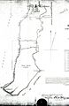
A historic image of a rancho, showing early land use.
-
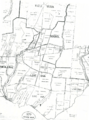
An 1889 map of the area, showing how the land was divided.
-
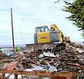
A house damaged by coastal erosion, showing the challenges of living by the sea.
See also
 In Spanish: Pleasure Point (California) para niños
