Point Coupee, Louisiana facts for kids
Quick facts for kids
Pointe Coupee
|
|
|---|---|
| Country | United States |
| State | Louisiana |
| Parish | Pointe Coupee |
| Elevation | 33 ft (10 m) |
| Time zone | UTC-6 (Central (CST)) |
| • Summer (DST) | UTC-5 (CDT) |
| GNIS feature ID | 515083 |
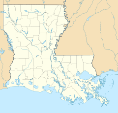
Pointe Coupee is the name of an unincorporated community. This means it's a group of homes and businesses that doesn't have its own local government. It is located in Pointe Coupee Parish, Louisiana, United States. The community is home to St. Francis Chapel. You can find it along Louisiana Highway 420, just north of New Roads. New Roads is the main town, or parish seat, of Pointe Coupee Parish.
Contents
History of Pointe Coupee
Pointe Coupee is a very old community. It was started in the 1720s by French colonists. These were people who came from France to live in a new land. It is one of the oldest places in the Mississippi River Valley.
Early Names and New Roads
When it was first founded, the community was called "Le Post de Pointe Coupée." This means the Pointe Coupee Post. Around 1776, a "chemin neuf" was built. This French phrase means new road. This new road connected the Mississippi River with False River. The area around this new road became known as New Roads. This is how the town of New Roads got its name.
The St. Francis Chapel
The Saint Francis Chapel in Pointe Coupee has a long history. The first chapel was finished in 1728. A new church building was built in 1760. However, it was too close to the Mississippi River. The river's waters started to wash away graves in the church's graveyard.
So, the church was taken down. A smaller church was built using materials from the old one. This newer building was officially opened in 1895. This church is special because it is the fourth-oldest Catholic church in Louisiana that has been used continuously. Today, St. Francis Chapel is a mission church. It is connected to St. Mary's of False River.
The town of St. Francisville is on the other side of the Mississippi River. It was named after the St. Francis Chapel.
Historical Events
In 1795, this area was part of New Spain. During this time, Pointe Coupee was the site of a major event. It was called the Pointe Coupée Conspiracy. This was a time when enslaved people on plantations in the area protested for their freedom. They burned down some homes belonging to plantation owners. This event happened just four years after another uprising. That one was called the 1791 Mina Conspiracy. It took place near New Roads.
 | Lonnie Johnson |
 | Granville Woods |
 | Lewis Howard Latimer |
 | James West |


