
Pontine Islands facts for kids

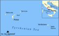
Map of the Pontine Islands
|
|
| Geography | |
|---|---|
| Location | Tyrrhenian Sea |
| Coordinates | 40°53′5″N 13°9′15″E / 40.88472°N 13.15417°E |
| Administration | |
| Demographics | |
| Demonym | Ponzesi |
| Population | 4076 |
The Pontine Islands are a small group of islands. They are located in the Tyrrhenian Sea, which is part of the Mediterranean Sea. You can find them off the west coast of Italy. These islands are about 30 to 40 kilometers (19 to 25 miles) from the Italian mainland.
The islands got their name from the biggest island in the group, which is called Ponza.
Contents
Exploring the Pontine Islands
The Pontine Islands cover an area of about 11.91 square kilometers (4.60 square miles). Around 4,076 people live there all year round. However, during the summer months, many more visitors come to enjoy the beautiful scenery.
You can reach the main islands, Ponza and Ventotene, by taking a ferry or a hydrofoil. These boats make it easy for people to travel to and from the islands.
Island Heights and Mountains
The highest point in the Pontine Islands is a mountain called Monte Guardia. It is located on the southern part of Ponza island. Monte Guardia stands tall at 283 meters (928 feet) above sea level.
Island Groups and Towns
The Pontine Islands are made up of six main islands and several smaller islets. These islands are divided into two groups. Each group belongs to a different comune (like a town or district) within the Latina province in Italy.
| Comune | Group | Main Islands | Population (2016) |
Area (km²) |
|---|---|---|---|---|
| Ponza | Northwestern group | Ponza, Palmarola, Zannone, Gavi | 3,337 | 10.16 |
| Ventotene | Southeastern group | Ventotene, Santo Stefano | 739 | 1.75 |
| Total | 4,076 | 11.91 | ||
Gallery
.png)


Images for kids
-
A map showing the Pontine Islands.
See also
 In Spanish: Islas Pontinas para niños
