Popanyinning, Western Australia facts for kids
Quick facts for kids PopanyinningWestern Australia |
|
|---|---|

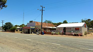
Popanyinning General Store, 2014
|
|
| Established | 1889 |
| Postcode(s) | 6309 |
| Area | [convert: needs a number] |
| Location | |
| LGA(s) | Shire of Cuballing |
| State electorate(s) | Central Wheatbelt |
| Federal Division(s) | O'Connor |
Popanyinning is a small town in Western Australia. It is located in the Wheatbelt region. This area is famous for its farming. The town is found along the Great Southern Highway. It sits between the towns of Pingelly and Narrogin. In 2016, about 180 people called Popanyinning home.
Contents
History of Popanyinning
How Popanyinning Got Its Name
The name "Popanyinning" has a special meaning. It comes from the local Noongar language. In Noongar, it means "water hole." This name was first recorded in 1869. It referred to a water hole in the Hotham River.
Early Days and Railway Life
The first settlers, called pioneers, arrived in 1893. Many of them were workers building the railway. Their families came with them. Popanyinning became one of the first stops, or "sidings," on the Great Southern Railway.
In 1903, the government set aside land for homes. This was to help the new settlers. The town was officially recognized in 1904.
Growing as a Trading Post
Within two years, 72 families lived in the area. Popanyinning became an important trading spot. Farmers could buy supplies there. They could also do business with people using the railway.
A hotel, the Popanyinning Hotel, was built in 1906. Many small shops also opened. The town was a busy place for a while.
Changes Over Time
After the 1920s, the town stopped growing. On July 9, 1978, the Popanyinning Hotel burned down. It was never rebuilt. Today, Popanyinning remains a small, quiet town.
 | Toni Morrison |
 | Barack Obama |
 | Martin Luther King Jr. |
 | Ralph Bunche |


