Port Julia, South Australia facts for kids
Quick facts for kids Port JuliaSouth Australia |
|||||||||||||||
|---|---|---|---|---|---|---|---|---|---|---|---|---|---|---|---|

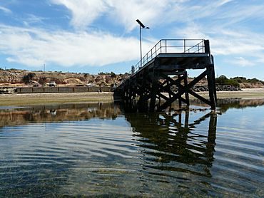
Port Julia Jetty
|
|||||||||||||||
| Established | 1999 | ||||||||||||||
| Postcode(s) | 5575 | ||||||||||||||
| Time zone | ACST (UTC+9:30) | ||||||||||||||
| • Summer (DST) | ACST (UTC+10:30) | ||||||||||||||
| Location | 72 km (45 mi) northwest of Adelaide city centre | ||||||||||||||
| LGA(s) | Yorke Peninsula Council | ||||||||||||||
| State electorate(s) | Narungga | ||||||||||||||
| Federal Division(s) | Grey | ||||||||||||||
|
|||||||||||||||
|
|||||||||||||||
| Footnotes | Location Coordinates Climate Localities |
||||||||||||||
Port Julia is a small place in South Australia, a state in Australia. It is also sometimes called Port Curramulka. You can find it on the eastern coast of the Yorke Peninsula. It's about 72 kilometers (45 miles) northwest of Adelaide city centre, which is the main city in South Australia.
History of Port Julia
Port Julia's official boundaries were set in May 1999. This was done to recognize a name that had been used for a long time. The area includes two older places: the Port Julia Shack Site and the Dipper Shack Site.
How Port Julia Got Its Name
The name Port Julia comes from a woman named Mrs. Julia Wurm. Her family, including her husband and sons, bought land in this area a long time ago. They decided to name the port after her.
What Port Julia Is Used For
In 2015, most of the land in Port Julia was used for agriculture. This means farmers grow crops or raise animals there.
Protecting Nature
Another important use of the land is for conservation. This means protecting nature. There is a special strip of land right along the coastline that is kept natural to help local plants and animals.
Homes by the Sea
Some parts of the coastline are also used for homes. These are often built where the old "shack sites" used to be. People enjoy living close to the sea.
Important Places in Port Julia
One of the most important spots in Port Julia is the Port Julia Jetty and Cargo Shed. A jetty is like a long pier that goes out into the water, often used for boats or fishing. A cargo shed is a building used to store goods.
A Special Landmark
This jetty and shed are very old and important. They are listed on the South Australian Heritage Register. This means they are protected because they are a significant part of the area's history and culture.
How Port Julia Is Governed
Port Julia is part of a few different government areas. These areas help manage the community and make decisions.
Local and State Government
At the local level, Port Julia is part of the Yorke Peninsula Council. This council helps with things like roads, parks, and local services. For state government, it's in the electoral district of Narungga.
Federal Government
At the national level, Port Julia is in the federal division of Grey. This is how people in Port Julia vote for their representatives in the Australian Parliament.
 | Emma Amos |
 | Edward Mitchell Bannister |
 | Larry D. Alexander |
 | Ernie Barnes |


