Port Sulphur, Louisiana facts for kids
Quick facts for kids
Port Sulphur, Louisiana
|
|
|---|---|

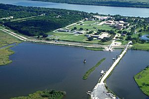
Aerial view of Port Sulphur, Louisiana on the Mississippi River
|
|
| Country | United States |
| State | Louisiana |
| Parish | Plaquemines |
| Area | |
| • Total | 8.41 sq mi (21.78 km2) |
| • Land | 5.41 sq mi (14.02 km2) |
| • Water | 3.00 sq mi (7.77 km2) |
| Elevation | 3 ft (0.9 m) |
| Population
(2020)
|
|
| • Total | 1,677 |
| • Density | 309.87/sq mi (119.65/km2) |
| Time zone | UTC-6 (CST) |
| • Summer (DST) | UTC-5 (CDT) |
| Zip code |
70083
|
| Area code(s) | 504 |
| FIPS code | 22-62070 |
Port Sulphur is a small community located on the West Bank of the Mississippi River in Plaquemines Parish, Louisiana, United States. It is known as a census-designated place (CDP). In 2020, about 1,677 people lived there.
Contents
How Port Sulphur Got Its Name
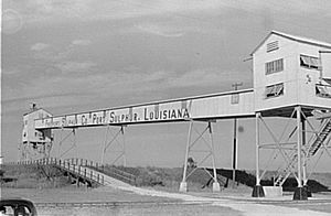
The community's name comes from the Freeport Sulphur Company. In the early 1930s, this company set up a big operation here. They handled the processing, storage, and shipping of sulphur. This sulphur came from their mine at Lake Grande Ecaille, which was about 10 miles west of the town.
The Grande Ecaille mine was the largest sulphur deposit in the world when it opened in 1933. It continued to produce sulphur until 1978. The Port Sulphur facility also supported other sulphur mines. These included mines at Garden Island Bay, Lake Pelto, and Caillou Island.
The company also used the facility to process sulphur recovered from oil and gas refining. The site was very useful because it was close to sulphur-producing areas. It also had good docking spots along the Mississippi River.
Port Sulphur's History
Port Sulphur started as a "company town." This means that the Freeport Sulphur Company owned most of the town's property. The lives of the residents were closely connected to the company. Over time, the company sold off much of its property. This made Port Sulphur more like a regular town with private land owners.
As fewer people worked at the sulphur facility, the company became less important to the town's daily life. Most of the company-owned land that was not needed for sulphur operations was given to Plaquemines Parish or sold. The Freeport Sulphur Company's business faced challenges in the 1980s and 1990s. This was due to competition from cheaper sulphur recovered from oil and gas.
In the early 2000s, Freeport Sulphur stopped its operations in Port Sulphur. The price of sulphur dropped too low. Large amounts of sulphur were being recovered from petroleum refining and Canadian natural gas. This made the expensive Frasch Process sulphur mining and storage uneconomical. The Freeport-McMoRan Port Sulphur facility was closed and sold.
Hurricane Katrina caused a lot of damage to the sulphur facility in August 2005. Only a few buildings remained. The large brick Plaquemines Parish Government building in town was originally the Freeport Sulphur Company's main office. The Port Sulphur school and other buildings were also once on company land.
The town faced economic difficulties after the Freeport Sulphur Mine closed.
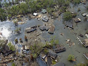
Port Sulphur is about 8 feet (2.4 meters) above sea level. It had not flooded during past hurricanes like Hurricane Betsy or Hurricane Camille. Before Hurricane Katrina and Hurricane Rita, about 3,000 people lived in Port Sulphur. However, during Hurricane Katrina, the federal levees failed. About 22 feet (6.7 meters) of water covered the town.
Almost all homes were destroyed. Many were moved far from their foundations. In the months after Katrina, some residents returned. They lived in trailers and temporary homes provided by the Federal Emergency Management Agency. But many people moved to other parts of Louisiana or other states.
By November 2006, the post office and several businesses had reopened. Street lights were added to Highway 23. By December 2007, about 1,500 residents lived in Port Sulphur. Most small businesses had started operating again.
Geography of Port Sulphur
Port Sulphur is located in Plaquemines Parish, Louisiana. The community has a total area of about 8.5 square miles (22 square kilometers). Of this, about 5.5 square miles (14 square kilometers) is land. The remaining 3.0 square miles (7.8 square kilometers) is water.
Fucich Bayou is a waterway located nearby.
Population Information
| Historical population | |||
|---|---|---|---|
| Census | Pop. | %± | |
| 2000 | 3,115 | — | |
| 2010 | 1,760 | −43.5% | |
| 2020 | 1,677 | −4.7% | |
| U.S. Decennial Census | |||
| Race / Ethnicity (NH = Non-Hispanic) | Pop 2000 | Pop 2010 | Pop 2020 | % 2000 | % 2010 | % 2020 |
|---|---|---|---|---|---|---|
| White alone (NH) | 1,404 | 419 | 356 | 45.07% | 23.81% | 21.23% |
| Black or African American alone (NH) | 1,379 | 1,136 | 1,013 | 44.27% | 64.55% | 60.41% |
| Native American or Alaska Native alone (NH) | 219 | 90 | 74 | 7.03% | 5.11% | 4.41% |
| Asian alone (NH) | 19 | 25 | 57 | 0.61% | 1.42% | 3.40% |
| Pacific Islander alone (NH) | 0 | 0 | 1 | 0.00% | 0.00% | 0.06% |
| Other race alone (NH) | 18 | 28 | 37 | 0.58% | 1.59% | 2.21% |
| Mixed race or Multiracial (NH) | 46 | 26 | 81 | 1.48% | 1.48% | 4.83% |
| Hispanic or Latino (any race) | 30 | 36 | 58 | 0.96% | 2.05% | 3.46% |
| Total | 3,115 | 1,760 | 1,677 | 100.00% | 100.00% | 100.00% |
In 2020, the population of Port Sulphur was 1,677 people.
Schools and Library
The Plaquemines Parish School Board manages the public schools in the parish.
- South Plaquemines Elementary School is located in Port Sulphur.
- Students attend South Plaquemines High School in Empire, which is near Buras.
Before 2005, Port Sulphur High School served the community. It taught students from pre-kindergarten through 12th grade. However, Hurricane Katrina damaged the original school building.
The Plaquemines Parish Library also has a branch in Port Sulphur.
See also
 In Spanish: Port Sulphur para niños
 | Leon Lynch |
 | Milton P. Webster |
 | Ferdinand Smith |


