Port William, Falkland Islands facts for kids
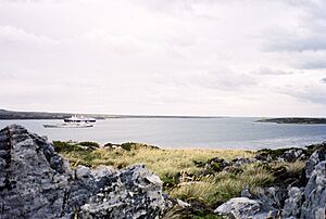
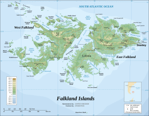
Port William is a large bay located on the east coast of East Falkland island. It is known as Baye Choiseul in French and Puerto Groussac in Spanish. A narrow passage called "the Narrows" connects Port William to Stanley Harbour.
Port William has several smaller bays and areas within it. These include Gypsy Cove and Yorke Bay, which are popular for their natural beauty. Hearnden Water is where the Murrell River and Weir Creek flow into the bay. Other areas are Blanco Bay and Sparrow Cove. Just north of Port William is Kidney Island.
A piece of land with Canopus Hill, Stanley Airport, and Gypsy Cove helps separate Port William from Stanley Harbour. A thin strip of land called Navy Point also helps with this division. This makes Port William the busiest waterway in the Falkland Islands. Many cruise ships, cargo ships, and navy vessels use this area. However, fewer ships visit now because there are two airports, RAF Mount Pleasant and Stanley Airport.
Port William was made larger over time by the movement of glaciers, which are huge sheets of ice.
History and Safety
After the Falklands War, many landmines were placed around Port William. These mines made the area dangerous. However, a big effort was made to clear them all. The very last mine was removed in November 2020, making the area safe again.
Plans for a New Port
In October 2012, the government of the Falkland Islands decided to look into building a new, larger port in Port William. The Executive Council of the Falkland Islands (ExCo) and members of the Legislative Assembly of the Falkland Islands (MLAs) asked officials to create plans and cost estimates for this new deep-water port. A deep-water port allows very large ships to dock easily. This project would also include other important buildings and services needed for the port.
See also
 In Spanish: Puerto Groussac para niños
 | Ernest Everett Just |
 | Mary Jackson |
 | Emmett Chappelle |
 | Marie Maynard Daly |


