
Porvenir, Chile facts for kids
Quick facts for kids
Porvenir
Karukinka
|
|||||
|---|---|---|---|---|---|
|
Town and Commune
|
|||||

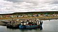
A view of Porvenir
|
|||||
|
|||||
| Country | |||||
| Region | |||||
| Province | Tierra del Fuego | ||||
| Founded | 1899 | ||||
| Government | |||||
| • Type | Municipality | ||||
| Area | |||||
| • Total | 6,982.6 km2 (2,696.0 sq mi) | ||||
| Elevation | 17 m (56 ft) | ||||
| Population
(2012 Census)
|
|||||
| • Total | 5,907 | ||||
| • Density | 0.84596/km2 (2.19103/sq mi) | ||||
| • Urban | 4,734 | ||||
| • Rural | 731 | ||||
| Demonym(s) | Porvenireño, -a | ||||
| Sex | |||||
| • Men | 3,307 | ||||
| • Women | 2,158 | ||||
| Time zone | UTC−3 (CLST) | ||||
| Area code(s) | 61 | ||||
| Climate | Cfc | ||||
| Website | Official website: http://www.muniporvenir.cl/ | ||||


Porvenir is a town in Chile. It is the capital of the Tierra del Fuego Province. This province is part of the Magallanes y la Antártica Chilena Region. Porvenir is one of the southernmost towns in Chile. About 4,700 people live here, including many soldiers. It is the biggest town on the Chilean side of the island of Tierra del Fuego.
The name Porvenir means "hereafter" or "yet to come" in Spanish. The town was started in 1883. People from Croatia and Chiloé came here. They were looking for gold, which led to a big gold rush in the area starting in 1884.
Today, the main jobs in Porvenir are sheep farming and small-scale fishing. There is also a Chilean army base in the town. Some gold is still mined here. Porvenir is also a way to reach Cerro Sombrero, which is an oil town about 125 kilometers (78 miles) away.
Contents
People of Porvenir

In 2002, a study showed that Porvenir had 5,465 people living there. Most of them (about 86%) lived in the town itself. The rest lived in the countryside nearby. The number of people living in Porvenir grew by 7.1% between 1992 and 2002.
How Porvenir is Governed
Porvenir is a "commune," which is a type of local government in Chile. It has a council and a leader called an "alcalde." The alcaldesa (female mayor) from 2016 to 2020 was Marisol Andrade Cárdenas. People vote for the alcalde every four years.
Visiting Porvenir

More and more tourists are visiting Porvenir. However, many people just pass through on their way to other places further south. The town has hotels, internet cafes, restaurants, and a gas station. You can also find several small shops and supermarkets.
You can get to Porvenir by ferry or by plane from Punta Arenas. You can also drive from the Argentine side of the island. Ferries cross the Straits of Magellan. One ferry goes daily (except Mondays) from a port near Punta Arenas to Porvenir. Another ferry service is at the northern end of the island. It runs from Punta Delgada to Bahia Azul.
From Porvenir, you can travel to the southern part of Chilean Tierra del Fuego. This area has many lakes and rivers where you can go fishing.
Weather in Porvenir
The climate in Porvenir is a cool oceanic climate. This means it has mild summers and cool, wet winters. In January and February, the warmest months, the average temperature is about 10.7°C (51.3°F). In July, the coolest month, the average temperature is about 1.7°C (35.1°F).
It rains about 749 millimeters (29.5 inches) each year. Because Porvenir is so far south, the amount of daylight changes a lot. In winter, there might be only seven hours of sunlight. In summer, the sun can be out for up to twenty hours! It can freeze any time of year. Sometimes, it even snows in the middle of summer. The highest temperature ever recorded was 32.2°C (90.0°F) in February 2019.
| Climate data for Porvenir (1991–2020, extremes 1986–present) | |||||||||||||
|---|---|---|---|---|---|---|---|---|---|---|---|---|---|
| Month | Jan | Feb | Mar | Apr | May | Jun | Jul | Aug | Sep | Oct | Nov | Dec | Year |
| Record high °C (°F) | 26.7 (80.1) |
32.2 (90.0) |
26.0 (78.8) |
20.8 (69.4) |
14.2 (57.6) |
13.2 (55.8) |
14.9 (58.8) |
13.6 (56.5) |
18.2 (64.8) |
20.9 (69.6) |
25.2 (77.4) |
27.4 (81.3) |
32.2 (90.0) |
| Mean daily maximum °C (°F) | 16.5 (61.7) |
15.8 (60.4) |
15.4 (59.7) |
12.4 (54.3) |
8.9 (48.0) |
6.3 (43.3) |
5.7 (42.3) |
7.1 (44.8) |
10.4 (50.7) |
12.9 (55.2) |
14.1 (57.4) |
16.0 (60.8) |
11.8 (53.2) |
| Daily mean °C (°F) | 10.8 (51.4) |
10.6 (51.1) |
9.1 (48.4) |
6.8 (44.2) |
4.2 (39.6) |
2.1 (35.8) |
1.7 (35.1) |
2.9 (37.2) |
4.7 (40.5) |
6.7 (44.1) |
8.6 (47.5) |
10.1 (50.2) |
6.5 (43.8) |
| Mean daily minimum °C (°F) | 4.8 (40.6) |
5.3 (41.5) |
4.0 (39.2) |
2.1 (35.8) |
0.1 (32.2) |
−1.3 (29.7) |
−1.9 (28.6) |
−1.0 (30.2) |
−0.5 (31.1) |
0.9 (33.6) |
3.3 (37.9) |
4.5 (40.1) |
1.7 (35.0) |
| Record low °C (°F) | −2.0 (28.4) |
−2.2 (28.0) |
−4.4 (24.1) |
−5.8 (21.6) |
−10.0 (14.0) |
−10.2 (13.6) |
−15.7 (3.7) |
−10.8 (12.6) |
−7.0 (19.4) |
−4.8 (23.4) |
−2.9 (26.8) |
−3.0 (26.6) |
−15.7 (3.7) |
| Average precipitation mm (inches) | 86 (3.4) |
65 (2.6) |
74 (2.9) |
74 (2.9) |
54 (2.1) |
47 (1.9) |
46 (1.8) |
49 (1.9) |
48 (1.9) |
56 (2.2) |
69 (2.7) |
81 (3.2) |
749 (29.5) |
| Average precipitation days | 15 | 12 | 12 | 11 | 9 | 8 | 9 | 9 | 10 | 11 | 13 | 15 | 134 |
| Average relative humidity (%) | 70 | 71 | 73 | 77 | 80 | 82 | 82 | 79 | 76 | 71 | 69 | 69 | 75 |
| Mean daily sunshine hours | 8.4 | 7.8 | 6.6 | 5.5 | 4.8 | 4.4 | 4.6 | 5.6 | 6.3 | 7.6 | 8.4 | 8.7 | 6.6 |
| Source 1: Climate-Data.org | |||||||||||||
| Source 2: Dirección Meteorológica de Chile (normal temperatures and extremes) | |||||||||||||
Images for kids
-
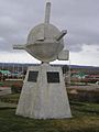
A monument to immigrants.
-
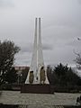
A monument in the main square.
-
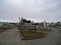
The Croatian Park.
-
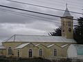
San Francisco De Sales Church
-
Porvenir.


See also
 In Spanish: Porvenir para niños
