Powersville, Missouri facts for kids
Quick facts for kids
Powersville, Missouri
|
|
|---|---|
|
Village
|
|

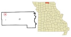
Location of Powersville, Missouri
|
|
| Country | United States |
| State | Missouri |
| County | Putnam |
| Area | |
| • Total | 0.57 sq mi (1.47 km2) |
| • Land | 0.56 sq mi (1.46 km2) |
| • Water | 0.00 sq mi (0.00 km2) |
| Elevation | 1,014 ft (309 m) |
| Population
(2020)
|
|
| • Total | 42 |
| • Density | 74.47/sq mi (28.75/km2) |
| Time zone | UTC-6 (Central (CST)) |
| • Summer (DST) | UTC-5 (CDT) |
| ZIP code |
64672
|
| Area code(s) | 660 |
| FIPS code | 29-59420 |
| GNIS feature ID | 2399015 |
Powersville is a small village located in the northwest part of Putnam County, Missouri, United States. In 2020, a count of the people living there, called a census, showed that 42 people lived in Powersville.
History of Powersville
Powersville was officially planned and marked out in 1887. This happened when the railroad tracks were extended to reach that area. The village was named after Israel Powers. He was the person who originally owned the land where the town was built. A post office has been open in Powersville since 1887, helping people send and receive mail.
Geography of Powersville
Powersville is found in the northwest part of Putnam County. It is located on Missouri Route E, about three miles west of Missouri Route 139. The town of Lucerne is six miles to the south. The border between Missouri and Iowa is just two miles north.
Medicine Creek flows about one mile to the west of the village. The old Chicago, Milwaukee, St. Paul and Pacific Railroad tracks also run along the west side of Powersville. The United States Census Bureau says that the village covers a total area of about 0.56 square miles (1.45 km2). All of this area is land.
Population of Powersville
| Historical population | |||
|---|---|---|---|
| Census | Pop. | %± | |
| 1920 | 356 | — | |
| 1930 | 285 | −19.9% | |
| 1940 | 294 | 3.2% | |
| 1950 | 227 | −22.8% | |
| 1960 | 189 | −16.7% | |
| 1970 | 125 | −33.9% | |
| 1980 | 116 | −7.2% | |
| 1990 | 38 | −67.2% | |
| 2000 | 86 | 126.3% | |
| 2010 | 60 | −30.2% | |
| 2020 | 42 | −30.0% | |
| U.S. Decennial Census | |||
The number of people living in Powersville has changed over the years. In 2010, the census showed that 60 people lived in the village. There were 33 households, which are groups of people living together. About 19 of these households were families.
Most of the people living in Powersville were White. A small number were from two or more different backgrounds. The average age of people in the village was about 61.5 years old. Many residents were 65 years old or older. The number of males and females in the village was about the same.
See also
 In Spanish: Powersville (Misuri) para niños
 | Mary Eliza Mahoney |
 | Susie King Taylor |
 | Ida Gray |
 | Eliza Ann Grier |

