
Prairie City, Iowa facts for kids
Quick facts for kids
Prairie City, Iowa
|
|
|---|---|
 |
|
| Nickname(s):
PC
|
|
| Motto(s):
"Proud Of Our Past, Confident Of Our Future."
|
|

Location of Prairie City, Iowa
|
|
| Country | |
| State | |
| County | Jasper |
| Area | |
| • Total | 1.24 sq mi (3.22 km2) |
| • Land | 1.24 sq mi (3.22 km2) |
| • Water | 0.00 sq mi (0.00 km2) |
| Elevation | 928 ft (283 m) |
| Population
(2020)
|
|
| • Total | 1,700 |
| • Density | 1,368.76/sq mi (528.67/km2) |
| Time zone | UTC-6 (Central (CST)) |
| • Summer (DST) | UTC-5 (CDT) |
| ZIP code |
50228
|
| Area code(s) | 515 |
| FIPS code | 19-64470 |
| GNIS feature ID | 0460389 |
Prairie City is a small city located in Jasper County, Iowa, in the United States. In 2020, about 1,700 people lived there. It's about 22 miles (35 km) east of Des Moines, a larger city. The city's motto is "Proud Of Our Past, Confident Of Our Future."
Contents
History of Prairie City
Prairie City was started in 1856 by James Elliott. It was first named after him. However, the name was changed because there was already another town called Elliott in Iowa. The very first person to live there was William Means. He built a tavern a couple of miles west of Elliott's cabin.
The railroad first came to Prairie City in 1866. This helped the town grow and connect with other places.
Schools in Prairie City
The first school in Prairie City was built in 1868. For many years, the city had its own school district. In 1990, the high school in nearby Monroe was destroyed by fire. Because of this, the Prairie City and Monroe school districts joined together. The new district is called Prairie City-Monroe (PCM) Community School District. Their sports teams are known as the PCM Mustangs.
Prairie City Historical Society
The Prairie City Historical Society was created in 1995. They work to preserve the city's history. You can visit the Prairie City Historical Museum at 109 S. Main Street. It's open by appointment. The museum has many old items from Prairie City's past. This includes the Dowden Potato Digger, which was first made right there in Prairie City.
Geography and Location
Prairie City is located at coordinates 41.598042 degrees North and -93.236726 degrees West.
The United States Census Bureau states that the city covers a total area of about 1.21 square miles (3.13 square kilometers). All of this area is land.
Population and People
| Historical populations | ||
|---|---|---|
| Year | Pop. | ±% |
| 1880 | 591 | — |
| 1890 | 684 | +15.7% |
| 1900 | 808 | +18.1% |
| 1910 | 764 | −5.4% |
| 1920 | 780 | +2.1% |
| 1930 | 793 | +1.7% |
| 1940 | 831 | +4.8% |
| 1950 | 834 | +0.4% |
| 1960 | 943 | +13.1% |
| 1970 | 1,141 | +21.0% |
| 1980 | 1,278 | +12.0% |
| 1990 | 1,366 | +6.9% |
| 2000 | 1,365 | −0.1% |
| 2010 | 1,680 | +23.1% |
| 2020 | 1,700 | +1.2% |
| Source: and Iowa Data Center Source: |
||
2020 Census Information
According to the census from 2020, Prairie City had 1,700 people living there. There were 651 households and 464 families. The city had about 1,369 people per square mile (528.7 per square kilometer).
Most people in Prairie City were White (94.6%). A small number were Black or African American (0.4%), Asian (0.8%), or from two or more races (3.8%). About 3.4% of the population was Hispanic or Latino.
The average age in the city was 37.5 years old. About 31.9% of the people were under 20 years old. Most households (55.9%) were married couples living together.
2010 Census Information
In the census of 2010, Prairie City had 1,680 people. There were 631 households and 468 families. The population density was about 1,388 people per square mile (536 per square kilometer).
Most residents were White (96.4%). About 1.5% of the population was Hispanic or Latino.
The median age was 33.7 years. About 31.1% of the people were under 18 years old.
Education in Prairie City
The PCM Community School District is in charge of the public schools that serve Prairie City. This district was formed on July 1, 1991, when the Prairie City School District merged with the Monroe district.
Prairie City is home to Prairie City Elementary School and PCM Middle School. Students from Prairie City attend PCM Community High School in Monroe.
Arts and Culture
Every year in June, Prairie City celebrates "Prairie Days." This is a special festival that honors the city's history and its "old settler" roots. It's a fun event for the community.
Parks and Recreation
Right next to Prairie City is the Neal Smith National Wildlife Refuge. This large area covers about 5,500 acres (22 square kilometers). It has been restored to look like Iowa's original rolling hills and tall grass prairies.
The refuge offers several miles of paved trails for walking or biking. There's also an auto tour where you can drive through the refuge. The Prairie Learning Center is a great place to learn about the local environment.
Prairie City also has several local parks. These parks offer sports facilities, playgrounds, and open spaces for everyone to enjoy.
Transportation
Prairie City is easy to reach by car. You can get there from the east and west using Highway 163. Highway 117 provides access from the north, and County Route S6G from the south.
Images for kids
-
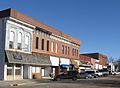
Downtown Prairie City
-
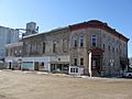
Another view of downtown Prairie City


See also
 In Spanish: Prairie City (Iowa) para niños
