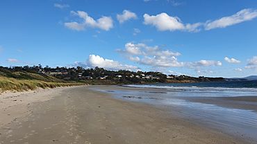
Primrose Sands, Tasmania facts for kids
Quick facts for kids Primrose SandsTasmania |
|||||||||||||||
|---|---|---|---|---|---|---|---|---|---|---|---|---|---|---|---|
 |
|||||||||||||||
| Population | 1,209 (2021) | ||||||||||||||
| Postcode(s) | 7173 | ||||||||||||||
| Location | |||||||||||||||
| LGA(s) | Sorell | ||||||||||||||
| Region | South-east | ||||||||||||||
| State electorate(s) | Lyons | ||||||||||||||
| Federal Division(s) | Lyons | ||||||||||||||
|
|||||||||||||||
Primrose Sands is a lovely seaside town in Tasmania, Australia. It's located in the Sorell area, which is in the south-east part of the state. This town is about 20 kilometers (about 12 miles) south-east of the larger town of Sorell.
In 2021, a count of people showed that 1209 people lived in Primrose Sands. It sits right by the ocean, where Frederick Henry Bay and Norfolk Bay meet. Even though many houses here are holiday homes, a lot of people live in Primrose Sands all year round.
The town has some useful places for everyone. There's a club called the Returned and Services League of Australia (RSL), a community center, and a shop that also works as a post office.
Contents
History of Primrose Sands
Primrose Sands officially became known as a "locality" (a specific place name) in 1972.
Naming Primrose Point
A part of the town called Primrose Point got its name a long time ago. In 1792, a French explorer named d'Entrecasteaux visited the area. On November 5, he named this point "Point Renard" after his ship's surgeon. Over time, the name changed to Primrose Point.
Where is Primrose Sands?
Primrose Sands is a coastal town. The western and southern edges of the town are right on the shore of Frederick Henry Bay. To the north, the Carlton River forms most of its boundary. This means the town is surrounded by beautiful water on several sides.
Getting Around Primrose Sands
The main road that helps people get around Primrose Sands is called C349, or Primrose Sands Road. This road comes into the town from the north-east and goes all the way through to the south-west, where it ends. It's the key route for traveling in and out of the area.
 | Mary Eliza Mahoney |
 | Susie King Taylor |
 | Ida Gray |
 | Eliza Ann Grier |


