Proctorsville, Vermont facts for kids
Quick facts for kids
Proctorsville, Vermont
|
|
|---|---|

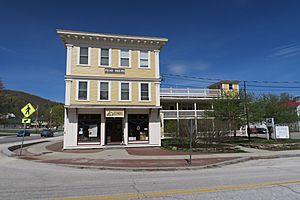
Pollard Block
|
|

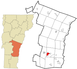
Location in Windsor County and the state of Vermont.
|
|
| Country | United States |
| State | Vermont |
| County | Windsor |
| Area | |
| • Total | 2.9 sq mi (7.6 km2) |
| • Land | 2.9 sq mi (7.4 km2) |
| • Water | 0.04 sq mi (0.1 km2) |
| Elevation | 931 ft (284 m) |
| Population
(2010)
|
|
| • Total | 454 |
| • Density | 154.7/sq mi (59.7/km2) |
| Time zone | UTC-5 (Eastern (EST)) |
| • Summer (DST) | UTC-4 (EDT) |
| ZIP code |
05153
|
| Area code(s) | 802 |
| FIPS code | 50-57400 |
| GNIS feature ID | 1459078 |
Proctorsville is a small community in Vermont, United States. It is known as a census-designated place (CDP). This means it is a specific area identified by the government for gathering population data.
Proctorsville is located within the larger town of Cavendish. It is part of Windsor County. In 2010, about 454 people lived in Proctorsville.
Exploring Proctorsville's Location
Proctorsville is found in the beautiful state of Vermont. Its center is just east of where two main roads meet. These roads are Vermont Route 131 and Vermont Route 103.
Rivers and Roads in Proctorsville
The Black River flows right through Proctorsville. Route 131 goes east from Proctorsville. It passes through Cavendish village and heads towards Ascutney. Route 103 travels west from Proctorsville. It leads to Ludlow. It also goes south through a place called Proctorsville Gulf to Chester.
See also
 In Spanish: Proctorsville para niños
 | Janet Taylor Pickett |
 | Synthia Saint James |
 | Howardena Pindell |
 | Faith Ringgold |


