
Ascutney, Vermont facts for kids
Quick facts for kids
Ascutney, Vermont
|
|
|---|---|

Proctor Library
|
|

Location in Windsor County and the state of Vermont.
|
|
| Country | United States |
| State | Vermont |
| County | Windsor |
| Area | |
| • Total | 1.7 sq mi (4.3 km2) |
| • Land | 1.7 sq mi (4.3 km2) |
| • Water | 0 sq mi (0.0 km2) |
| Elevation | 413 ft (126 m) |
| Population
(2020)
|
|
| • Total | 529 |
| • Density | 319/sq mi (123.0/km2) |
| Time zone | UTC-5 (Eastern (EST)) |
| • Summer (DST) | UTC-4 (EDT) |
| ZIP Codes | |
| Area code(s) | 802 |
| FIPS code | 50-01750 |
| GNIS feature ID | 1456178 |
Ascutney is a small community in the state of Vermont, United States. It's known as an "unincorporated village" and a "census-designated place" (CDP). This means it's a recognized community, but it doesn't have its own separate local government like a city or town.
Ascutney is part of the larger town of Weathersfield in Windsor County. It's located in the northeastern part of Weathersfield. The village gets its name from the nearby Mount Ascutney, a prominent mountain in the area. In 2010, about 540 people lived in Ascutney.
Exploring Ascutney's Location
Ascutney is found in a beautiful part of Vermont. It sits at about 43 degrees North latitude and 72 degrees West longitude. This location places it near the southern slopes of Mount Ascutney. The very top of Mount Ascutney is in the neighboring towns of Windsor and West Windsor.
Roads and Travel in Ascutney
Getting around Ascutney is easy thanks to several important roads. U.S. Route 5 runs right through the village, going north and south. In the center of Ascutney, it meets Vermont Route 12 and Vermont Route 131.
Interstate 91 forms the western edge of Ascutney. You can get to Ascutney from Interstate 91 by taking Exit 8. If you follow Route 12 from Ascutney, it will take you across the Connecticut River into Claremont, New Hampshire.
Images for kids
-
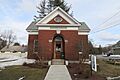
Proctor Library, a local landmark in Ascutney.
See also
 In Spanish: Ascutney para niños
