
Mount Ascutney facts for kids
Quick facts for kids Mount Ascutney |
|
|---|---|

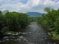
Mount Ascutney from Claremont, New Hampshire
|
|
| Highest point | |
| Elevation | 3,144 ft (958 m) |
| Prominence | 2,270 ft (690 m) |
| Listing | #25 on New England Fifty Finest |
| Geography | |

Mount Ascutney
Location in Vermont

Mount Ascutney
Location in the United States
|
|
| Topo map | USGS Mount Ascutney |
| Climbing | |
| Easiest route | Hike |
Mount Ascutney is a mountain located in the U.S. state of Vermont. Standing at 3,144 feet (958 meters) tall, it is the second-highest peak in Windsor County. The tallest mountain in the county is Gillespie Peak.
Mount Ascutney is a special kind of mountain called a monadnock. This means it's a tall, lonely mountain that stands out sharply from the flat land around it. For example, the Windsor Trail is about 2.7 miles (4.3 km) long and climbs over 2,500 feet (762 meters), which is a pretty steep climb! The mountain is known for its granite rock formations. One of these, near the top, is a popular spot for hang gliders to launch.
The base of Mount Ascutney touches several small towns. These include Ascutney, Brownsville, Windsor, and West Windsor. The mountain is also very close to Interstate 91 and is part of Mount Ascutney State Park. You can even see Mount Ascutney from the top of Mount Washington, which is 70 miles (110 km) away!
Contents
Where is Mount Ascutney?
Mount Ascutney is in the southeastern part of Windsor County. It sits in the Connecticut River Valley. The village of Ascutney is to the south. To the north are the towns of Windsor and West Windsor. The village of Brownsville is at the mountain's northwestern base. To the east, you'll find the Connecticut River and the city of Claremont, New Hampshire. Right next to it on the west is a smaller mountain called Little Ascutney Mountain.
What Does the Name "Ascutney" Mean?
Since the Colonial era, people have mostly called this mountain "Mount Ascutney." This name became official in 1960. Many people believe the name "Ascutney" comes from the Abenaki word Ascutegnik. This word means "at the end of the river fork." It was the name of a settlement near where the Sugar River meets the Connecticut River.
However, another Abenaki word, Kaskadenak, has also been used for the mountain. This word means "mountain of the rocky summit" or "wide mountain." The official board that names places knows about this other name. In 2016, a local resident asked to change the official name to Kaskadenak. The Chief of the Koasek Traditional Band of the Abenaki Nation supported this idea.
In 2018, the State of Vermont Board of Libraries looked into officially renaming the mountain. They decided not to change the name. They heard from town managers who said local people did not want the name to change. A language expert from the Smithsonian also said that both "Ascutney" and "Kaskadenak" are real Abenaki names for the mountain. Both names mean "wide mountain" and come from different times and ways of speaking the Native American language.
How to See Mount Ascutney
You can get great views of Mount Ascutney from different roads. Vermont Route 131 follows the south side of the mountain. Vermont Routes 44 and 44-A follow the north side. Interstate 91, which runs north-south, gives wide views of both the north and south sides. In New Hampshire, Routes 12 and 12-A offer good views of the east side. It's hard to see the west side because Little Ascutney Mountain is in the way.
You can also see Mount Ascutney from far away, especially from other hilltops and mountains. For example, you can spot it from certain buildings on the Dartmouth College campus.
Artists Who Loved the View
From the late 1880s to 1930, a group of artists lived and worked in nearby Cornish and Plainfield, New Hampshire, as well as Windsor, Vermont. This was known as the Cornish Art Colony. Many artists, like Augustus Saint-Gaudens, built their homes so they would have a perfect view of Mount Ascutney. The mountain became a main feature in their large gardens and fancy Italian-style houses. Famous artists like Maxfield Parrish, Charles Platt, Thomas Dewing, and the writer Winston Churchill all built homes to enjoy the mountain view. Many of these houses are still there today, with their beautiful views. The home of Augustus Saint-Gaudens is now a national park, and it has a lovely view of the mountain.
The Mountain's History: Geology
Mount Ascutney is made of igneous rocks. These rocks formed when hot, melted rock cooled and hardened deep inside the Earth. This happened about 122 million years ago. The mountain is about 8 km (5 miles) long and 4 km (2.5 miles) wide. It pushed up through older rocks in the area. Scientists think this happened because of cracks in the Earth's crust during a time when the land was trying to pull apart. The mountain is made of three main types of rock: gabbro-diorite, syenite, and granite. There are also many smaller rock formations around it.
The last glacier that covered this area broke off pieces of the mountain. It carried these pieces southward into Massachusetts. The path of these rocks is sometimes called the "Mount Ascutney Train."
Flying High: Hang Gliding
Mount Ascutney is a very popular spot for hang gliding in New England. It's known for having excellent conditions for soaring. It's common for hang gliders to fly from Mount Ascutney to nearby states. Some flights can even go all the way to the coast of New Hampshire or Massachusetts, which is over 90 miles (140 km) away!
Wildlife on the Mountain
You can often see many different animals on Mount Ascutney. Wild turkeys, deer, and porcupines are common. There are also many kinds of birds. The mountain is a favorite place for watching migrating birds. These birds use the Connecticut River as a guide during their long journeys. Less common animals you might see include moose, black bears, bobcats, and fishers.
Hiking Trails
Mount Ascutney has four main hiking trails. Three of them are named after the towns where they start:
- The Weathersfield Trail — This trail is on the south side of the mountain. You can find its start in a parking lot at the end of Cascade Falls Road, off Vermont Route 131 in Weathersfield. Highlights of this trail include Cascade Falls, which is the biggest waterfall on the mountain. It also has the mountain's only launch platform for hang gliders.
- The Windsor Trail — This trail starts from a small parking area off Vermont Route 44-A. About a third of the way up, you'll find a small waterfall. About two-thirds of the way up, there's a small log lean-to shelter. Near the top, it joins with the Brownsville Trail.
- The Brownsville Trail — This trail begins at a parking area along Vermont Route 44. The lower part of the trail follows an old logging road for a while. This road ends at an old granite quarry. The trail offers many good views to the north and west.
- The Futures Trail — This trail starts in the campground at Mount Ascutney State Park on Route 44A. It's the longest trail on Mount Ascutney, at 4.6 miles (7.4 km). It goes through many different types of forests and landscapes before connecting to the Windsor Trail near the top. Fun spots on this trail include Bare Rock Vista and the Steam Donkey. The Steam Donkey is an old machine used for moving logs in the early 1900s. You can also start this trail from two points along the State Park Mountain Road for a shorter hike to the top.
At the top of the mountain, a fairly flat trail follows the ridgeline and crosses the summit. The very top of the mountain is covered in trees. However, there are several rocky cliffs that offer great views. One special viewpoint, The Nowlan Lookout, is named after a local artist, Lawrence Nowlan. There is also an observation tower and two large communications towers at the top.
You can also reach the summit by taking a short trail from the parking lot at the end of the only road up the mountain, the Mount Ascutney State Park Mountain Road.
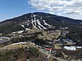
Skiing at Ascutney Mountain Resort

Mount Ascutney used to be home to the Ascutney Mountain Resort. This was a ski resort located on the mountain's northwest side, in the village of Brownsville. It opened after World War II. At first, it only had one rope tow for skiers.
In 2008, a company bought the resort property and has been working to improve it. The mountain and its trails were bought by a non-profit group called Vermont Outdoors. Now, it is run as a town forest for Brownsville, Vermont. The trails are good for families, but expert and intermediate skiers especially enjoyed the resort. Its trails were often steep and could be icy because of the mountain's strong winds. Other popular ski resorts nearby included Killington, Okemo, Mount Sunapee, and Stratton.
Images for kids
-
Mount Ascutney from Claremont, New Hampshire
-
Aerial view of Mount Ascutney
