
Puerto Carrillo facts for kids
Quick facts for kids
Puerto Carrillo
|
|
|---|---|
|
District
|
|

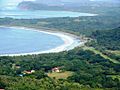
Aerial view of Carrillo
|
|

Puerto Carrillo
Location in Costa Rica
|
|
| Country | |
| Province | Guanacaste |
| Canton | Hojancha |
| Creation | 23 July 1999 |
| Area | |
| • Total | 76.75 km2 (29.63 sq mi) |
| Elevation | 40 m (130 ft) |
| Population
(2011)
|
|
| • Total | 1,574 |
| • Density | 20.508/km2 (53.116/sq mi) |
| Time zone | UTC−06:00 |
| Postal code |
51103
|
Puerto Carrillo is a lovely district located in the Guanacaste region of Costa Rica. It's part of the Hojancha area and is known for its beautiful Pacific Coast beaches.
Contents
History of Puerto Carrillo
Puerto Carrillo was officially created as a district on July 23, 1999. Before that, it was part of the Hojancha area.
Geography and Location
Puerto Carrillo covers an area of about 76.75 square kilometers (around 29.6 square miles). It sits at an elevation of 40 meters (about 131 feet) above sea level.
This district is found along the Pacific Coast of Costa Rica. The main town of Puerto Carrillo is quite small, with fewer than 500 people living there full-time. It's mostly a quiet village, famous for sport fishing. You'll find a few nice hotels, restaurants, small food shops, and tour companies here.
If you're looking for more options, the town of Sámara is only 4 kilometers (about 2.5 miles) away. The people who live in Carrillo are mostly local residents, which helps the area keep its true Costa Rican feel. The entire district has a population of around 1,800 people.
What to Do in Puerto Carrillo
Fun Activities and Beaches
Puerto Carrillo is a calm and welcoming community. For over 15 years, it has been a popular spot for sport fishing, especially for catching large fish like billfish. The small harbor keeps the boats safe.
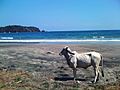
The main beach, Playa Carrillo, has beautiful white sand and usually small waves. It's a great place for swimming and for families with kids. Playa Carrillo is rarely crowded, and it has nice picnic areas right on the beach. You can easily park your car close by, making it simple to enjoy your day in the sand.
There are also other pretty and quiet beaches nearby:
- El Roble is a rocky beach with its own waterfall and cool tide pools to explore.
- Playa El Sur is a beautiful medium-sized beach surrounded by palm trees. You can only reach this beach by boat.
- Playa Samara, located 4 kilometers (about 2.5 miles) north, is a much bigger beach. The waves here are usually knee to waist high, making it a popular spot for beginner surfers and families.
Population in Puerto Carrillo
| Historical population | |||
|---|---|---|---|
| Census | Pop. | %± | |
| 2000 | 1,287 | — | |
| 2011 | 1,574 | 22.3% | |
|
Instituto Nacional de Estadística y Censos |
|||
According to the 2011 census, Puerto Carrillo had a population of 1,574 people.
Getting Around Puerto Carrillo
Roads and Travel
The district of Puerto Carrillo is connected by several main roads:
 National Route 158
 National Route 160
 National Route 901
Carrillo is about 41 kilometers (25 miles) from Nicoya. Nicoya is a bigger town and an important center for the region.
The roads leading to Carrillo are paved, which makes travel much easier. The paving of "Road 150," which goes from Nicoya through Sámara to Carrillo, was finished in early 2006. This made it much faster and simpler to get to the area.
Now, it takes about 4 hours to drive from San Jose's Juan Santamaría International Airport (SJO) to Carrillo. From Liberia's Daniel Oduber International Airport (LIR), it takes less than 2 hours. Public buses run between nearby Sámara and Nicoya several times a day. There are also express buses that connect Sámara with San José usually twice a day, except on weekends.
There used to be an airport nearby called Carrillo Airport, which had air service from Sansa Airlines, but it is no longer in use.
Villages in the District
The main village and administrative center of the district is Puerto Carrillo itself.
Other small villages in the district include:
- Angostura
- Arbolito
- Cuesta Malanoche
- Estrada Rábago
- Jobo
- Lajas
- Quebrada Bonita (partly)
- San Miguel
- Santa María
Gallery
-
Aerial photo of Carrillo Beach
-
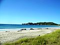
Carrillo Beach
-
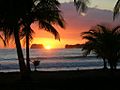
Carrillo Beach Sunset
-
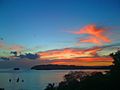
Carrillo Beach Sunset
-
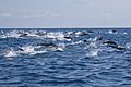
Spinner dolphins right off the coast of Carrillo
-
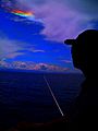
Fire rainbow right off the coast of Carrillo
-
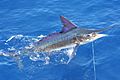
Stripe marlin right off the coast of Carrillo
-
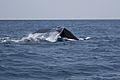
Humpback whale fluking right off the coast of Carrillo
-


See also
 In Spanish: Puerto Carrillo para niños
