Puerto Rico, Pando facts for kids
Quick facts for kids
Puerto Rico (Pando)
|
|
|---|---|
|
Town
|
|

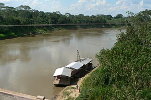
Orthon River, Puerto Rico, Bolivia
|
|
| Country | |
| Department | |
| Province | Manuripi Province |
| Elevation | 574 ft (175 m) |
| Population
(2013)
|
|
| • Total | 2,872 |
| Time zone | UTC-4 (BOT) |
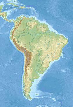
Puerto Rico is a small town in the northern part of Bolivia. It's located in the Pando Department, which is like a state or province. This town is special because it's inside the Manuripi-Heath Amazonian Wildlife National Reserve. This means it's surrounded by amazing nature!
Puerto Rico was founded a long time ago, on May 18, 1890. For a while, it was even the main city of the Pando Department, before Cobija became the capital. Puerto Rico is built right where two rivers meet: the Manuripi River and the Tahuamanu River. When these two rivers join, they form the Orthon River.
Every year in June, something exciting happens here. The International Recreational Fishing Championship of Puerto Rico takes place at this river meeting point. The Orthon River then flows for about 410 kilometers (about 255 miles) before it joins the bigger Beni River.
Climate and Environment
Puerto Rico is in the lowlands of Bolivia. This area is part of the huge Amazon River system. The land around the town is mostly tropical rainforest. This means it's very green and full of different plants and animals.
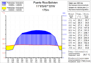
The average temperature in this region is around 26.5 degrees Celsius (about 80 degrees Fahrenheit). The temperature stays pretty much the same all year round. The area gets a lot of rain, about 1,800 millimeters (71 inches) each year.
The rainiest time is from December to March, when it can rain over 200 millimeters (8 inches) in a month. The drier season is from June to August, when it might only rain about 30 millimeters (1.2 inches) a month.
Getting Around Puerto Rico
Puerto Rico is located 169 kilometers (about 105 miles) east of Cobija. Cobija is the capital city of the Pando Department. Puerto Rico is an important place for crossing the river on the main road, called Ruta 13.
Ruta 13 is a highway that is 370 kilometers (about 230 miles) long. It starts from Cobija and goes east through a town called Porvenir to Puerto Rico. In Puerto Rico, the road crosses the Río Orthon. Then it continues to a place called El Triangulo (also known as El Choro). At El Choro, Ruta 13 connects with another important road, Ruta 8. Ruta 8 goes from northern towns like Guayaramerín and Riberalta to central Bolivian lowlands, including Reyes, Rurrenabaque, and Yucumo.
Population Growth
The number of people living in Puerto Rico has been growing steadily over the years. This information comes from the official Bolivian Census.
- In 1992, the town had 509 people.
- By 2001, the population had grown to 1,522 people.
- The most recent census in 2013 showed that 2,872 people lived in Puerto Rico.
This shows that more and more people are choosing to live in this interesting town in the Amazon rainforest.
See also
 In Spanish: Puerto Rico (Pando) para niños
 | William M. Jackson |
 | Juan E. Gilbert |
 | Neil deGrasse Tyson |


