
Rurrenabaque facts for kids
Quick facts for kids
Rurrenabaque
|
|||
|---|---|---|---|
|
Town and municipality
|
|||
 |
|||
|
|||

Rurrenabaque
Location in Bolivia
|
|||
| Country | |||
| Department | |||
| Province | José Ballivián Province | ||
| Elevation | 899 ft (274 m) | ||
| Population
(2012)
|
|||
| • Total | 19,195 | ||
| Time zone | UTC-4 (BOT) | ||


Rurrenabaque is a small town in northern Bolivia. It sits right on the Beni River. This town is the main city of the Rurrenabaque Municipality.
In recent years, Rurrenabaque has become a popular spot for visitors from all over the world. It is a great starting point for trips into the Bolivian rainforest. You can also explore the nearby pampas, which are wide grasslands. Locals often call the town "Rurre" for short.
Rurrenabaque is part of José Ballivián Province in the Beni Department of Bolivia. In 2012, the Rurrenabaque Municipality had 19,195 people. About 13,446 of them lived in the town of Rurrenabaque itself.
Contents
Getting to Rurrenabaque
You can reach Rurrenabaque in a few ways. It is about 410 km (250 mi) from La Paz, the capital city.
- By bus: A bus trip takes about 18 hours from La Paz.
- By taxi: A hired taxi can get you there in about 12 hours.
- By plane: Flying is the fastest way, taking only 45 minutes to 1 hour. Ecojet is one airline that flies to Rurrenabaque.
Roads and Airports

The buses from La Paz pass through a town called Coroico. This town is about 70 km (43 mi) from La Paz. A new road opened in 2006. This new road made travel safer than the old Yungas Road. The old road was also known as 'Death Road' and is now popular for mountain bike tours.
The Rurrenabaque Airport had its runway paved in 2010. Sometimes, low clouds over the mountains nearby can make it hard for planes to land.
Another airport you can use is Reyes Airport. It is about 32 kilometres (20 mi) away from Rurrenabaque. A bus ride from Reyes takes about one hour. Reyes Airport often has better weather and fewer low clouds because there are no mountains nearby. Reyes is the main town of José Ballivián Province.
The Beni River Bridge
Rurrenabaque is on the east side of the Beni River. A bridge now connects it to the town of San Buenaventura on the west side. Before the bridge, people had to cross the river by boat. This was often difficult and costly. The bridge helps the two towns connect better and makes travel easier for everyone.
Rurrenabaque's Climate
Rurrenabaque is located where the Beni River leaves the Andes Mountains. It then flows into the flat lands called the Llanos de Moxos. The city has a tropical rainforest climate. This means it is warm and wet for most of the year. There is also a slightly drier period.
| Climate data for Rurrenabaque (Rurrenabaque Airport), elevation 204 m (669 ft) | |||||||||||||
|---|---|---|---|---|---|---|---|---|---|---|---|---|---|
| Month | Jan | Feb | Mar | Apr | May | Jun | Jul | Aug | Sep | Oct | Nov | Dec | Year |
| Mean daily maximum °C (°F) | 31.4 (88.5) |
31.1 (88.0) |
31.5 (88.7) |
31.1 (88.0) |
29.3 (84.7) |
28.1 (82.6) |
28.4 (83.1) |
30.5 (86.9) |
32.0 (89.6) |
32.6 (90.7) |
32.1 (89.8) |
31.8 (89.2) |
30.8 (87.5) |
| Daily mean °C (°F) | 26.6 (79.9) |
26.4 (79.5) |
26.4 (79.5) |
25.7 (78.3) |
23.9 (75.0) |
22.6 (72.7) |
22.1 (71.8) |
23.4 (74.1) |
25.0 (77.0) |
26.4 (79.5) |
26.6 (79.9) |
26.7 (80.1) |
25.2 (77.3) |
| Mean daily minimum °C (°F) | 21.8 (71.2) |
21.7 (71.1) |
21.3 (70.3) |
20.3 (68.5) |
18.5 (65.3) |
17.1 (62.8) |
16.0 (60.8) |
16.5 (61.7) |
18.1 (64.6) |
20.1 (68.2) |
20.9 (69.6) |
21.6 (70.9) |
19.5 (67.1) |
| Average precipitation mm (inches) | 318.2 (12.53) |
306.6 (12.07) |
241.2 (9.50) |
157.9 (6.22) |
131.2 (5.17) |
129.3 (5.09) |
87.9 (3.46) |
73.0 (2.87) |
77.2 (3.04) |
135.2 (5.32) |
192.8 (7.59) |
256.1 (10.08) |
2,106.6 (82.94) |
| Average precipitation days | 15.1 | 14.6 | 13.6 | 9.3 | 9.2 | 9.0 | 6.6 | 4.9 | 5.4 | 8.0 | 10.2 | 12.7 | 118.6 |
| Average relative humidity (%) | 81.8 | 83.9 | 83.2 | 80.5 | 81.0 | 82.9 | 77.2 | 73.2 | 71.5 | 74.9 | 77.7 | 81.0 | 79.1 |
| Source: Servicio Nacional de Meteorología e Hidrología de Bolivia | |||||||||||||
Tourism and Eco-Adventures
Rurrenabaque is a popular spot for ecotourism. From here, you can go on exciting tours into the jungle or rainforest. This area is called "selva" in Spanish. You can also visit the nearby pampas.
Jungle and Pampas Tours
The jungle and rainforest areas are to the south and west of Rurrenabaque. They include part of Madidi National Park. Tours usually involve boat rides and walking. Many tour companies in town offer similar trips.
Eco-Lodges and Community Tourism
Rurrenabaque is known for its eco-lodges. These are places where you can stay that are built to protect nature. Some of these eco-lodges are run by local communities. This helps support the people living there.
Here are some of the community-based eco-lodges:
- Mashaquipe
- San Louis Grande (Mosetén community)
- Berraco del Madidi (Quechua-Tacanas community)
- San Miguel del Bala (Tacanas community)
- Chalalán (Quechua-Tacanas community)
- Mapajo (Tsiman-Mosetén community)
Local Events
One important event is the Fiesta de Rurre. This celebration happens on February 2nd. It marks the anniversary of Rurrenabaque and honors La Virgen de Candelaria.
Images for kids
-
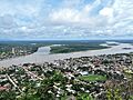
A view of Rurrenabaque town.
-

The flag of Rurrenabaque.
-
The coat of arms of Rurrenabaque.
See also
 In Spanish: Rurrenabaque para niños
