Puig Campana facts for kids
Quick facts for kids Puig Campana |
|
|---|---|

Puig Campana
|
|
| Highest point | |
| Elevation | 1,406 m (4,613 ft) |
| Geography | |
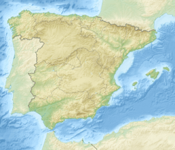
| Location | Marina Baixa, Province of Alicante, Valencian Community |
| Country | Spain |
| Parent range | Prebaetic System |
| Climbing | |
| First ascent | Unknown |
| Easiest route | From Finestrat |

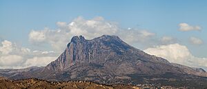
Puig Campana (which means Bell Peak in English) is a tall mountain in the southeast of Spain. It's part of the Prebaetic System mountain range. Standing at 1,406 meters (about 4,613 feet) high, it's the second-tallest peak in the province of Alicante. Puig Campana is located in the town of Finestrat, only about 10 kilometers (6 miles) from the beautiful Mediterranean Sea coast.
From the bottom, it might look like Puig Campana has only one peak. But actually, it has two! The taller peak is a bit hidden from below. The western peak has a special crack or notch. This feature has been known for a long time as El Portell (The Gate). Sometimes, people also call it Roldan's Notch.
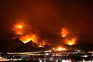
A large part of the trees on the northeast side of the mountain were burned in a wildfire in 2009. The fire started on January 24 when a strong wind blew over an electricity pylon. About 1,000 hectares (2,471 acres) of land were burned. Around 15,000 people had to leave their homes in nearby towns. Experts are now studying the best ways to help the mountain's plants grow back.
The Legend of Puig Campana
The famous notch in Puig Campana's western peak has inspired many cool stories. These are often different versions of the same legend.
One popular story is similar to a legend from the Pyrenees mountains. It says that a brave French hero named Roland, who led Charlemagne’s army, fought a Moorish army leader. Their duel ended on top of Puig Campana. At one point, Roland knocked his enemy to the ground. He lifted his powerful sword, Durandarte, to finish the fight. But he missed! His sword hit the mountain with such force that it cut a huge chunk out of it. This giant rock then fell into the sea. People say this rock is still visible today as Benidorm Island! The gash Roland made in the mountain's peak still carries his name.
There are many versions of this legend. In another story, Roland's girlfriend, Alda, was fated to die when the last ray of sun touched her. To give her a few more moments of life, Roland cut a piece out of the mountain. This made the sun take longer to set, letting Alda live a little bit longer.
Climbing Puig Campana
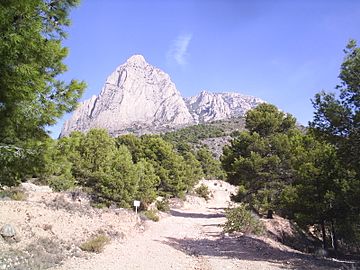
You can climb Puig Campana using several different paths. Many of these paths meet up before reaching the very top. You can get maps and information at the tourism office in downtown Finestrat. There's also a small information point at the trailhead, which is at Font del Molí.
However, the trail can be hard to follow. In many places, it's just a narrow footpath. The painted symbols on rocks that mark the way are small and faded. The mountain also has steep slopes with loose rocks and thick bushes. Because of this, it's easy to get lost. So, it's a really good idea to talk to the tourist office before you go. Let them know you are planning to hike. Local people say that many tourists get lost and need to be rescued.
Always remember to bring water, food, and a mobile phone. There are no shops or services along the way. From the trailhead, climbing to the top and back usually takes about 5 to 8 hours. If you just want to walk around the base of the mountain without going to the summit, it takes about 4 to 5 hours.
The most direct way to climb is from Finestrat. You start at Font del Molí and head towards the mountain's south side. From here, you'll see a long, steep slope covered in loose rocks (called scree). You can climb straight up this scree slope, but it's not very pleasant. Or, you can follow a trail that runs next to the scree slope on the right side. Both the trail and the scree slope have faded red painted symbols. It's easy to lose the trail if it's foggy or misty. From the top of the scree slope, the trail turns east towards the summit. There are many paths that cross each other here, which can make the route hard to follow in the mist.
See also
 In Spanish: Puig Campana para niños
- Mountains of the Valencian Community
- Aitana (1,559 m), the highest mountain of Alicante province.


