Bessemer Township, Michigan facts for kids
Quick facts for kids
Bessemer Township, Michigan
|
|
|---|---|

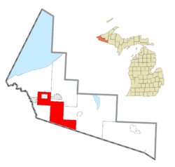
Location within Gogebic County
|
|
| Country | United States |
| State | Michigan |
| County | Gogebic |
| Area | |
| • Total | 115.4 sq mi (298.9 km2) |
| • Land | 113.8 sq mi (294.9 km2) |
| • Water | 1.6 sq mi (4.0 km2) |
| Elevation | 1,549 ft (472 m) |
| Population
(2020)
|
|
| • Total | 1,135 |
| • Density | 11.2/sq mi (4.3/km2) |
| Time zone | UTC-6 (Central (CST)) |
| • Summer (DST) | UTC-5 (CDT) |
| ZIP code(s) | |
| Area code(s) | 906 |
| FIPS code | 26-07980 |
| GNIS feature ID | 1625929 |
Bessemer Township is a community located in Gogebic County, in the U.S. state of Michigan. It's like a local government area that includes several smaller communities. In 2020, about 1,135 people called Bessemer Township home.
Contents
About Bessemer Township
Bessemer Township is quite large! It covers about 115 square miles (298 square kilometers). Most of this area is land, but it also has some water, like lakes or rivers. The highest point in the township is about 1,549 feet (472 meters) above sea level.
Who Leads Bessemer Township?
The township has leaders who help run things. The main leader is called the Supervisor, and their name is Jeffery Randall. There is also a Clerk, Debbie Janczak, who helps with official records and meetings.
Communities in Bessemer Township
Bessemer Township is made up of several smaller communities, each with its own history. Many of these places were important for mining in the past.
Anvil Location
Anvil Location started in 1886. It was built around the Anvil Mine, which dug for iron. This mine was active for 70 years, from 1887 to 1957. Anvil Location even had its own post office for many years, from 1918 to 1971.
City of Bessemer
The City of Bessemer is located within the township. However, it has its own separate government and rules. It's like a town inside a larger county area.
Dunham
Dunham was a community that grew around a train station. It was on the Chicago and Northwestern Railroad line. There was also a factory here called the Ashland Iron and Steel Company. Dunham had a post office from 1902 to 1911.
Harding Location
Harding Location is a farming community on the southern edge of the township. While some farming still happens here, it's not as much as it used to be.
Puritan Location
Puritan Location is the community furthest to the west. It was also established in 1886. Its mine, called the Ruby, was run by the Oliver Mining Company. This mine was one of the first big iron mines in the area to close, shutting down in 1941. Puritan Location had a large public school building, built in 1920, which stayed open until 1959. It also had a post office from 1910 to 1953.
Ramsay
Ramsay is another community in the township. It's located on the Black River. You can find it just south of U.S. Highway 2. Ramsay is a few miles west of Wakefield and a few miles east of Bessemer.
The Keystone Arch Bridge
One cool landmark in Ramsay is the Keystone Arch Bridge. It was built in 1891 by the Chicago & Northwestern Railway. The bridge cost about $48,322 back then. It was made using strong limestone rocks from Kaukauna, Wisconsin.
The Keystone Arch Bridge is 45 feet (14 meters) long, 44 feet (13 meters) wide, and 57 feet (17 meters) tall. It also has special "wing walls" that are 50 feet (15 meters) long. Bridges made of stone arches are quite rare in Michigan, making this one special!
Population Over Time
In 2010, there were 1,176 people living in Bessemer Township. By 2020, the population was 1,135 people.
See also
 In Spanish: Municipio de Bessemer para niños
 | Sharif Bey |
 | Hale Woodruff |
 | Richmond Barthé |
 | Purvis Young |


