Putney, Georgia facts for kids
Quick facts for kids
Putney, Georgia
|
|
|---|---|

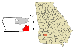
Location in Dougherty County and the state of Georgia
|
|
| Country | United States |
| State | Georgia |
| County | Dougherty |
| Area | |
| • Total | 22.13 sq mi (57.31 km2) |
| • Land | 22.02 sq mi (57.03 km2) |
| • Water | 0.11 sq mi (0.28 km2) |
| Elevation | 200 ft (61 m) |
| Population
(2020)
|
|
| • Total | 2,869 |
| • Density | 130.28/sq mi (50.30/km2) |
| Time zone | UTC-5 (Eastern (EST)) |
| • Summer (DST) | UTC-4 (EDT) |
| ZIP code |
31782
|
| Area code(s) | 229 |
| FIPS code | 13-63084 |
| GNIS feature ID | 0332767 |
Putney is a small place in Dougherty County, Georgia, United States. It is called an "unincorporated community" and a "census-designated place" (CDP). This means it's a recognized area for counting people, but it doesn't have its own city government.
In 2020, about 2,869 people lived in Putney. It is part of the larger Albany, Georgia area.
Contents
History of Putney
Putney got its name from a local landowner, Francis F. Putney. A post office was opened here in 1897. This helped the community grow and connect with other places.
Where is Putney Located?
Putney is in the southeastern part of Dougherty County. Its exact location is 31°28′23″N 84°7′17″W / 31.47306°N 84.12139°W.
The southern edge of Putney is next to Mitchell County. The Flint River forms part of its western border.
Highways and Travel
U.S. Route 19 is the main highway that goes through Putney. It is also known as the Liberty Expressway. This road helps people travel easily.
You can drive north about 7 miles (11 km) to reach Albany. If you go south, it's about 50 miles (80 km) to Thomasville.
Land and Water Area
Putney covers a total area of about 22.1 square miles (57.3 square kilometers). Most of this area is land. Only a small part, about 0.11 square miles (0.28 square kilometers), is water.
People of Putney
Putney is home to a diverse group of people. The population changes over time. Here's how the number of people living in Putney has changed:
| Historical population | |||
|---|---|---|---|
| Census | Pop. | %± | |
| 1990 | 3,108 | — | |
| 2000 | 2,998 | −3.5% | |
| 2010 | 2,898 | −3.3% | |
| 2020 | 2,869 | −1.0% | |
| U.S. Decennial Census | |||
Community Life
In 2000, there were almost 3,000 people living in Putney. They lived in about 1,138 homes. Many of these homes were families, including married couples and single-parent households.
The average household had about 2 to 3 people. The average family had about 3 people.
Age Groups
The people in Putney are of all ages. In 2000:
- About 24% of the people were under 18 years old.
- About 27% were between 25 and 44 years old.
- About 28% were between 45 and 64 years old.
- About 12% were 65 years old or older.
The average age of people in Putney was 39 years.
Income Information
In 2000, the average income for a household in Putney was about $40,953 per year. For families, the average income was about $44,244 per year.
Some people in Putney lived below the poverty line. This included about 17% of all people and 27% of those under 18 years old.
Neighborhoods in Putney
Putney has different areas, or neighborhoods, where people live. Two of these are:
- Hollands Folly
- Loretta Heights
See also
 In Spanish: Putney (Georgia) para niños
 | DeHart Hubbard |
 | Wilma Rudolph |
 | Jesse Owens |
 | Jackie Joyner-Kersee |
 | Major Taylor |


