
Puyo, Pastaza facts for kids
Quick facts for kids
Puyo
|
|
|---|---|
| Nuestra Señora del Rosario de Pompeya de Puyo | |

From top, left to right: Aerial view of the city, monument to the indigenous groups of Pastaza, Our Lady of the Rosary Cathedral, viewpoint next to the Puyo River, monument to the Indian-mestizo Forge, Pastaza Governorate, Amazon State University, Puyo Bus Station and Ethno-archaeological Museum.
|
|

Puyo
Location in Ecuador
|
|
| Country | |
| Province | |
| Canton | Pastaza Canton |
| Foundation | November 10, 1899 |
| Founded by | Unnamed Catholic priest |
| Named for | Puyu, meaning "clouds" in Quichua |
| Government | |
| • Type | Mayor and council |
| Area | |
| • City | 8.49 km2 (3.28 sq mi) |
| Elevation | 950 m (3,116 ft) |
| Population
(2022 census)
|
|
| • City | 33,325 |
| • Density | 3,925.2/km2 (10,166/sq mi) |
| • Demonym | Puyense |
| Time zone | UTC-5 (ECT) |
| Postal code |
EC160150
|
| Area code(s) | (+593) 4 |
| Climate | Af |
Puyo (pronounced POO-yo) is the capital city of Pastaza Province in Ecuador. It sits about 950 meters (3,116 feet) above sea level. The city is located by the Puyo River, which flows into the Pastaza River and eventually reaches the mighty Amazon River.
The name Puyo comes from the Kichwa word for "cloudy." This makes sense because the area has a very wet climate, and the sky is often overcast. Puyo was founded in 1899.
Today, Puyo is an important center for business, culture, and government in its region. It is located between the cities of Baños, Tena, and Macas. In 2022, Puyo had a population of 33,325 people. The weather here doesn't change much throughout the year. Daytime temperatures usually stay between 18 and 24 degrees Celsius (64 to 75 degrees Fahrenheit). You can expect sunshine, but also short, heavy rain showers every day.
Contents
History of Puyo

For a long time, the eastern part of Ecuador, including the area where Puyo is now, was not very developed. Missionaries, traders, and people looking for gold and spices like cinnamon would travel through.
In the late 1800s, the Ecuadorian government started to pay more attention to the Amazon region. They gave missionaries power to help govern these areas.
How Puyo Was Founded
The city of Puyo was officially founded on May 12, 1899. A Dominican missionary named Alvaro Valladares, along with nine local Canelos indigenous people, found the perfect spot. They were looking for a place to rest during their journeys between Baños and Canelos. They found this ideal location near the Puyo River, where the Central Park is today.
The missionaries built three large huts and placed a wooden cross there. They held a special Mass, dedicating the new settlement to the Virgin Mary. They named it Our Lady of the Rosary of Pompeii, Puyo.
At first, only native people lived in the new village. Later, traders from other areas started using it as a stopping point on their trips.
Geography and Climate
Puyo has a tropical rainforest climate. This means it gets a lot of rain all year round. It's located at a higher elevation (950 meters or 3,116 feet) than many other places with this climate. Because of this, Puyo's temperatures are a bit cooler.
The average temperature in Puyo is about 20.8 degrees Celsius (69.4 degrees Fahrenheit). The city receives a lot of rainfall, averaging about 4,536 millimeters (178.6 inches) each year.
| Climate data for Puyo, elevation 960 m (3,150 ft), (2000–2013) | |||||||||||||
|---|---|---|---|---|---|---|---|---|---|---|---|---|---|
| Month | Jan | Feb | Mar | Apr | May | Jun | Jul | Aug | Sep | Oct | Nov | Dec | Year |
| Mean daily maximum °C (°F) | 26.5 (79.7) |
26.2 (79.2) |
26.4 (79.5) |
26.8 (80.2) |
26.2 (79.2) |
25.7 (78.3) |
25.6 (78.1) |
26.7 (80.1) |
27.4 (81.3) |
27.8 (82.0) |
27.5 (81.5) |
26.7 (80.1) |
26.6 (79.9) |
| Daily mean °C (°F) | 21.3 (70.3) |
21.3 (70.3) |
21.3 (70.3) |
21.4 (70.5) |
19.7 (67.5) |
20.7 (69.3) |
20.5 (68.9) |
20.9 (69.6) |
21.2 (70.2) |
21.9 (71.4) |
21.9 (71.4) |
21.5 (70.7) |
21.1 (70.0) |
| Mean daily minimum °C (°F) | 17.8 (64.0) |
18.0 (64.4) |
17.9 (64.2) |
18.0 (64.4) |
18.1 (64.6) |
17.5 (63.5) |
16.9 (62.4) |
16.6 (61.9) |
16.6 (61.9) |
17.5 (63.5) |
17.9 (64.2) |
18.0 (64.4) |
17.6 (63.6) |
| Average precipitation mm (inches) | 304.0 (11.97) |
315.0 (12.40) |
408.0 (16.06) |
474.0 (18.66) |
418.0 (16.46) |
443.0 (17.44) |
366.0 (14.41) |
341.0 (13.43) |
362.0 (14.25) |
388.0 (15.28) |
367.0 (14.45) |
327.0 (12.87) |
4,513 (177.68) |
| Average relative humidity (%) | 89 | 86 | 88 | 91 | 90 | 91 | 89 | 88 | 87 | 88 | 89 | 90 | 89 |
| Source 1: Instituto Nacional de Meteorología e Hidrología | |||||||||||||
| Source 2: FAO (precipitation 1971–2000) | |||||||||||||
Transportation in Puyo
Puyo is connected by roads to other important cities like Ambato, Tena, and Macas. From these cities, you can reach other major areas in Ecuador.
There's a small airport located in the town of Shell, which is about 10 kilometers (6 miles) northwest of Puyo. Small planes, both private and commercial, fly daily from here to little airstrips deep in the Amazon Rainforest. Sometimes, flights also go to Quito for serious medical emergencies.
Culture and Celebrations
Puyo celebrates the Puyo Carnaval every year. This is a famous Ecuadorian holiday that takes place in the days leading up to Lent. During Carnaval, people often have small parties in their neighborhoods. Sometimes, fun water fights are part of the celebration!
Other important holidays include the Day of the Ecuadorian East Amazon, celebrated on February 12. There's also the chonta-palm festival, which celebrates a local plant.
Images for kids
-
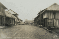
The main street of Puyo, around 1900.
See also
 In Spanish: Puyo para niños
