
Tena, Ecuador facts for kids
Quick facts for kids
Tena
|
|
|---|---|
|
City
|
|

From top, left to right: View of the city center and the Tena River, cable-stayed bridge of the Amazon Park The Island, night view of the Boardwalk, monument to the Quichua ethnic group, monument to Jumandy, November 15 avenue and Tena Park.
|
|
| Nickname(s):
Cinnamon Capital
|
|

Tena, Ecuador
Location in Ecuador
|
|
| Country | |
| Province | |
| Canton | Tena |
| Founded | 1560 |
| Area | |
| • City | 7.42 km2 (2.86 sq mi) |
| Elevation | 598 m (1,962 ft) |
| Population
(2022 census)
|
|
| • City | 29,724 |
| • Density | 4,005.9/km2 (10,375/sq mi) |
| Demonym(s) | Tenense (spanish) |
| Time zone | UTC-5 (ECT) |
| Area code(s) | (+593) 6 |
| Climate | Af |
| Website | www.tena.gob.ec |
Tena is a city located in the Amazon rainforest of Ecuador. It is the main city of Napo Province and also its capital. Tena is known for its beautiful natural surroundings and is often called the "Cinnamon Capital."
Contents
History of Tena
Tena is one of several cities in Ecuador that were founded by a Spanish explorer named Gil Ramírez Dávalos. He was a conquistador, which means a Spanish leader who helped conquer new lands. Dávalos was in charge of the area of Quito from 1556 to 1559. He also founded other important cities like Cuenca in 1557 and Baeza in 1560.
Geography of Tena
Tena is located where two rivers, the Tena and Pano, meet. This meeting point is called a confluence. Right in the middle of the city, at this confluence, you'll find the Parque Amazónico La Isla. It's a park with a cool pedestrian bridge called el Puente Espiral.
After the Tena and Pano rivers join, they become the Tena River. This river then flows into the Misahualli. Finally, it joins the Napo River. The Napo River is a very large river and is one of the biggest rivers that flows into the mighty Amazon River further east in Peru.
Climate in Tena
Tena is located in a rainforest, about 420 meters (1,378 feet) above sea level. This means it gets a lot of rain all year long. On average, it receives about 4,360 millimeters (171.65 inches) of rain each year. The rainiest months are usually April, May, and June.
| Climate data for Tean, elevation 527 m (1,729 ft), (1971–2000) | |||||||||||||
|---|---|---|---|---|---|---|---|---|---|---|---|---|---|
| Month | Jan | Feb | Mar | Apr | May | Jun | Jul | Aug | Sep | Oct | Nov | Dec | Year |
| Mean daily maximum °C (°F) | 28.5 (83.3) |
28.3 (82.9) |
28.3 (82.9) |
27.9 (82.2) |
27.6 (81.7) |
27.2 (81.0) |
27.4 (81.3) |
28.5 (83.3) |
29.3 (84.7) |
29.1 (84.4) |
28.7 (83.7) |
29.1 (84.4) |
28.3 (83.0) |
| Mean daily minimum °C (°F) | 18.6 (65.5) |
18.3 (64.9) |
18.3 (64.9) |
18.2 (64.8) |
18.4 (65.1) |
18.0 (64.4) |
17.8 (64.0) |
17.9 (64.2) |
18.5 (65.3) |
18.6 (65.5) |
18.6 (65.5) |
18.5 (65.3) |
18.3 (65.0) |
| Average precipitation mm (inches) | 323.0 (12.72) |
293.0 (11.54) |
389.0 (15.31) |
500.0 (19.69) |
477.0 (18.78) |
531.0 (20.91) |
498.0 (19.61) |
339.0 (13.35) |
379.0 (14.92) |
435.0 (17.13) |
377.0 (14.84) |
335.0 (13.19) |
4,876 (191.99) |
| Average relative humidity (%) | 88 | 87 | 88 | 90 | 88 | 93 | 89 | 88 | 86 | 87 | 87 | 86 | 88 |
| Source: FAO | |||||||||||||
Tourism and Activities
Tena is a popular place for tourists because of its amazing rainforest and many rivers. There are many affordable hotels, tour companies, and restaurants that welcome visitors, especially those who like to travel on a budget, often called "backpackers." The city is surrounded by green hills and sits at the edge of the Andes mountains, which you can see to the west.
The rivers in this part of the Amazon are big and always have plenty of water. This makes Tena a great starting point for exciting jungle adventures. People come here for kayaking and rafting tours in Ecuador's Amazon rainforest.
When you enter the city, you'll see a statue of a local hero named Jumandy. He was an indigenous leader who fought against the Spanish in 1578. He is remembered for his bravery.
Many people also come to Tena to volunteer for projects that help replant trees in the rainforest. These projects often work with local communities to support things like ecotourism. Ecotourism helps people visit nature responsibly and supports the local economy. The native people of Ecuador are very organized. Tena is home to two major groups: Fenakin and Ashin.
Getting Around Tena
The road from Quito to Tena is mostly paved, making travel easier. The journey includes a beautiful drive over Papallacta Pass, which is very high up in the mountains. On clear days, you might even see the Sumaco volcano.
You can take a bus from Quito to Tena, which takes about 4 hours. If you travel by private car, it's a bit faster, around 3 to 3.5 hours. Once you're in the city, there are many small yellow truck-taxis that can take you around for a small fee.
Tena used to have an airport called Mayor Galo de la Torre Airport, but it closed in 2011. A new airport, Jumandy Airport, opened in 2011. It is located about 27 kilometers (17 miles) east of Tena, near Ahuano. For a while, an airline called TAME flew there, but they stopped flights in 2016 because not enough people were using them.
Gallery
-
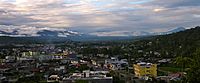
Tena (2011)
-
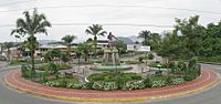
Statue of Jumandy at the city entrance
-
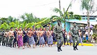
Soldiers of the Jungle Commands Group parading in Tena
-
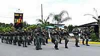
Soldiers of the Jungle Commands Group parading in Tena
-
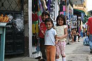
Local children
-
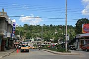
Street in Tena (2009)
-
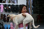
Child with dog


.jpg)
.jpg)
.jpg)
See also
 In Spanish: Tena (Ecuador) para niños
