Pwllgwaelod facts for kids
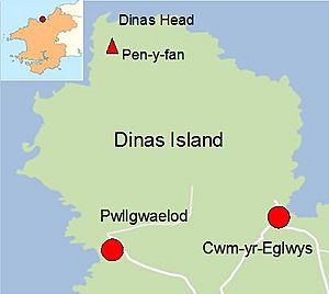
Pwllgwaelod (pronounced Pwll-gwa-el-od) is a small, spread-out village located on a pretty bay. It sits on the southwest side of the Dinas Island peninsula in Wales. This charming spot is part of the Dinas Cross community, found between the towns of Fishguard and Newport, Pembrokeshire. Many of the homes in Pwllgwaelod are used as holiday cottages, perfect for visitors wanting to explore the beautiful Welsh coast.
Contents
Exploring Pwllgwaelod Beach
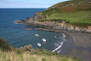
Pwllgwaelod is known for its lovely sandy beach. It's quite wide and open, with soft, dark sand. High cliffs and rocks on both sides protect the beach, making it a calm place. This means it's not really suitable for water sports like surfing, but it's great for relaxing! From the beach, you can enjoy fantastic views across Fishguard Bay, looking towards Fishguard Harbour.
In 2011 and 2012, the beach's water quality didn't meet some standards. This might have happened because of a lot of rain, which washed water from the land into the sea during two very wet summers. However, a nearby beach called Cwm-yr-Eglwys has won special awards for its clean water and beautiful coast.
Getting to Pwllgwaelod
Reaching Pwllgwaelod involves driving down a narrow, winding road from the center of Dinas Cross. This village is located right on the A487 main road.
Travel by Bus
During the summer months, from May to September, you can also get to Pwllgwaelod by bus! There's a special bus service called the "Poppit Rocket." This bus travels along the coastline, connecting Fishguard in the south to Cardigan in the north. It's a great way to see the scenery without needing a car.
Walking the Coastal Path
Pwllgwaelod is a stop on the famous Pembrokeshire Coast Path. From here, you can walk about 3 miles all the way around the Dinas Island peninsula. This path will take you to Cwm-yr-Eglwys, which is on the other side of the peninsula.
There's also a shorter, direct footpath to Cwm-yr-Eglwys. It's a little over a mile long and goes through a valley that almost separates Dinas Head from the mainland. This path is even suitable for wheelchairs, making it accessible for more people.
Facilities for Visitors
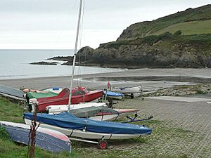
When you visit Pwllgwaelod, you'll find two car parks, so there's usually space to park. There are also public toilets available. If you have a small boat, there's a special area called a boat-park with a slipway. This allows you to easily launch small boats like dinghies into the water. Good news for pet owners: dogs are allowed on Pwllgwaelod beach!
The Old Sailors Pub
Right by the beach, you'll find a historic pub that's now a bar and restaurant called The Old Sailors. This is the only building directly on the beach. It has been used for about 500 years, though it was closed for a while starting in 1994.
A Guiding Light
The pub was once known as the Sailors Safety. It's believed to have been built in 1593. Its old name came from a light that was kept burning there. This light helped guide ships safely into the cove, especially in bad weather. The famous Welsh writer Dylan Thomas even visited this pub at least once!
A Historic Harbour and Lime Kiln
Pwllgwaelod was sometimes used as a safe harbour. When strong winds from the east made Fishguard Harbour dangerous, ships could find shelter here.
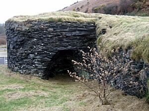
Near the beach, there's a medium-sized lime kiln. A lime kiln is a special oven used to heat limestone. Limestone was brought to Pwllgwaelod by boat. When heated in the kiln, it turned into "quicklime." This quicklime was then used on the land, especially on Dinas Island, to improve the soil for farming.
Pwllgwaelod in Stories
Pwllgwaelod has appeared in old books and stories.
Sailing Directions
In 1870, a book called "Sailing directions for the West Coast of England" mentioned Pwllgwaelod. It said: There is a similar but smaller beach, the Pwll-gwaelod, which terminates a small strip of swamp that lies within Dinas head, and almost insulates it. This beach has better shelter than that of Goodie*, and small vessels frequently beach upon it in fine weather and easterly winds. This means Pwllgwaelod offered good shelter for small boats, especially when winds came from the east. (*Goodie Sands was near Fishguard.)
A Fairy City Legend
In 1905, Sabine Baring-Gould wrote about a local legend in his book "A Book of South Wales" It tells a magical story about Pwllgwaelod: Now the story goes that under the sea by Dinas Point, in Pwll Gwaelod, lies a fairy city inhabited by a mysterious people called the Bendith y Mamau (the Blessing of the Mothers). When the sea is calm, through the crystal waters can be seen the golden roofs and spires and marble palaces of the underwater folk. The vision lasts for from five to ten minutes at a time. One day a ship of a Dinas fisherman cast anchor in the Pwll, when up the chain came swarming one of these subaqueous people, who stepped on deck and said to the captain, "What is this that you are doing? Your anchor is in the roof of my house." The captain promised to disengage it and not cast anchor there again. This fun legend suggests that a hidden fairy city lies beneath the waves of Pwllgwaelod!
 | Misty Copeland |
 | Raven Wilkinson |
 | Debra Austin |
 | Aesha Ash |


