
Pyrocumulonimbus cloud facts for kids
A pyrocumulonimbus cloud is a special type of cumulonimbus cloud that forms above very hot places. Think of it like a giant storm cloud, but instead of forming from regular weather, it grows from intense heat sources. These heat sources can be huge wildfires or powerful volcanic eruptions. People sometimes call them "fire clouds" because they are created by fire.
Contents
What is a Pyrocumulonimbus Cloud?
A pyrocumulonimbus cloud is a massive cloud that looks a lot like a regular thunderstorm cloud. However, it gets its energy from intense heat on the ground, not just from warm, moist air. The name "pyrocumulonimbus" combines "pyro" (meaning fire), "cumulus" (meaning heap, like a puffy cloud), and "nimbus" (meaning rain cloud).
How Do These Fire Clouds Form?
These clouds form when a very strong heat source, like a large wildfire or a volcano erupting, sends a huge amount of hot air, smoke, and ash high into the atmosphere.
- As this superheated air rises, it carries moisture and smoke with it.
- When it reaches cooler air higher up, the moisture condenses, forming a cloud.
- The continuous heat from below keeps pushing the cloud higher and higher, making it grow very tall, just like a regular cumulonimbus cloud.
- This process can create its own weather system, separate from the usual atmospheric conditions.
What Do They Look Like?
Pyrocumulonimbus clouds often have a dark, smoky appearance, especially at their base, due to all the ash and soot they carry. They can tower miles into the sky, sometimes reaching the stratosphere, which is a very high layer of Earth's atmosphere. From a distance, they might look like a regular storm cloud, but closer up, you can see the smoke and fire influencing their shape.
Effects of Pyrocumulonimbus Clouds
These powerful clouds can have several effects, especially when they form over wildfires:
- Lightning: They can create their own lightning, which can start new fires in dry areas, making wildfires even worse.
- Strong Winds: The rising and falling air within the cloud can create strong, gusty winds near the ground.
- Fire Tornadoes: In extreme cases, the intense heat and swirling winds can even lead to the formation of "fire tornadoes" or "fire whirls." These are spinning columns of fire that can be very dangerous.
- Ashfall: They can carry ash and smoke for hundreds of miles, causing poor air quality and ashfall in distant areas.
Historical Examples
Pyrocumulonimbus clouds have been observed during major events throughout history:
- One famous example is the cloud that formed over Hiroshima, Japan, after the atomic bomb blast in 1945. For a long time, people thought it was the mushroom cloud from the bomb itself. However, scientists later realized it was a pyrocumulonimbus cloud created by the massive firestorm that followed the explosion.
- More recently, large wildfires in places like Australia, California, and Argentina have produced many pyrocumulonimbus clouds, showing their power and impact on the environment.
Images for kids
-
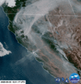
A satellite image of the formation of a cumulonimbus flammagenitus over Argentina in 2018.
-
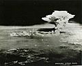
For decades, the plume in this "Hiroshima strike" photo was misidentified as the mushroom cloud (itself a type of cumulonimbus flammagenitus) from the atomic bomb blast on 6 August 1945. However, due to its much greater height, the cloud was identified in March 2016 as the cumulonimbus flammagenitus cloud produced above the city by the subsequent firestorm, which reached its peak intensity some three hours after the explosion.
-
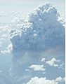
Picture of a cumulonimbus flammagenitus cloud, taken from a commercial airliner cruising at about 10 km altitude.
-
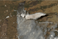
Animation of the formation of a pyrocumulonimbus above the 2020 Creek Fire in California


See also
 In Spanish: Cumulonimbus flammagenitus para niños
