
Quapaw, Oklahoma facts for kids
Quick facts for kids
Quapaw, Oklahoma
|
|
|---|---|
| Town of Quapaw | |

Main façade of the Quapaw Town Hall
|
|
| Nickname(s):
"The Hay Capital"
|
|

Location in Ottawa County and Oklahoma
|
|

Quapaw, Oklahoma
Location in the United States
|
|
| Country | |
| State | |
| County | Ottawa |
| Incorporated | 1917 |
| Area | |
| • Total | 0.98 sq mi (2.53 km2) |
| • Land | 0.98 sq mi (2.53 km2) |
| • Water | 0.00 sq mi (0.00 km2) |
| Elevation | 843 ft (257 m) |
| Population
(2020)
|
|
| • Total | 811 |
| • Density | 830.94/sq mi (320.75/km2) |
| Time zone | UTC-6 (Central (CST)) |
| • Summer (DST) | UTC-5 (CDT) |
| ZIP code |
74363
|
| Area code(s) | 539/918 |
| FIPS code | 40-61400 |
| GNIS feature ID | 2412515 |
| Highways |
|
Quapaw, officially known as the Town of Quapaw, is a small town in Ottawa County, Oklahoma, United States. It is the official capital of the Quapaw Nation. The town is located about 9 miles (14 km) northeast of Miami and is part of the Joplin, Missouri area. Quapaw became an official town in 1917. In 2020, about 811 people lived there.
Contents
History of Quapaw
Early Settlement and Growth
In 1891, a farmer named Isaac Bingham and his family moved to Ottawa County. This area was then part of the land set aside for the Quapaw Nation. Later, in 1907, this land became part of the new state of Oklahoma.
The Bingham family started a community and opened several businesses. Chief John Quapaw of the Quapaw Nation generously gave land for a community school. A railroad company, the Kansas City, Fort Scott and Memphis Railroad, built a stop and a side track here. This made it easier to send hay and other farm products to markets, which brought more settlers to the area. A post office opened in the community's grocery store in 1897.
Becoming an Official Town
Leaders in the community planned a "New Town Quapaw" on land they bought from Harry Whitebird, a member of the Quapaw Nation. This "new" town officially became Quapaw in 1917.
Around this time, people discovered lead and zinc ores in the area. This led to a big mining boom as part of the Tri-State mining district. Thousands of miners moved to the region, causing the population to grow quickly.
Route 66 and Population Changes

Ottawa County had many people from different Native American tribes, including the Quapaw. The growing population and economy helped new businesses start. By 1920, Quapaw had 1,394 residents.
In the 1920s, the famous U. S. Route 66 was built through Quapaw. The road was paved through Ottawa County by 1933. This was a big event! Quapaw Chief Victor Griffin placed a special zinc tablet in the middle of Main Street to celebrate.
After World War II, the local mining operations started to slow down. This meant fewer jobs in the area, and the population began to shrink. By 1940, only 1,054 people lived in Quapaw, and by 1960, it was down to 850. The mining left behind large piles of leftover rock and waste, called chat.
Geography
Quapaw is located in Oklahoma. It covers about 0.98 square miles (2.53 square kilometers), and all of this area is land. The town is about 9 miles (14 km) north of Miami. It is the last town you pass through in Oklahoma on U.S. Highway 69A before reaching the Kansas state line.
Population Information
| Historical population | |||
|---|---|---|---|
| Census | Pop. | %± | |
| 1920 | 1,394 | — | |
| 1930 | 1,340 | −3.9% | |
| 1940 | 1,054 | −21.3% | |
| 1950 | 938 | −11.0% | |
| 1960 | 850 | −9.4% | |
| 1970 | 967 | 13.8% | |
| 1980 | 1,097 | 13.4% | |
| 1990 | 928 | −15.4% | |
| 2000 | 984 | 6.0% | |
| 2010 | 906 | −7.9% | |
| 2020 | 811 | −10.5% | |
| U.S. Decennial Census | |||
In 2000, there were 984 people living in Quapaw. These people lived in 352 households, with 258 of them being families. The town had about 1,759 people per square mile (679 people per square kilometer).
About 31.5% of households had children under 18. Many households (52.8%) were married couples. About 22.4% of all households were individuals living alone. The average household had 2.72 people.
The age of people in Quapaw varied. About 28.7% were under 18, and 16.1% were 65 or older. The average age was 35 years old.
Education
The public schools in the Quapaw area are run by Quapaw Public Schools.
Images for kids
-
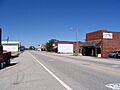
Historic Route 66 in Quapaw (2008)
See also
 In Spanish: Quapaw (Oklahoma) para niños
