Queenscliff, New South Wales facts for kids
Quick facts for kids QueenscliffSydney, New South Wales |
|||||||||||||||
|---|---|---|---|---|---|---|---|---|---|---|---|---|---|---|---|

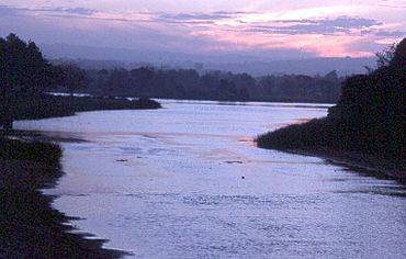
Manly Lagoon, dusk
|
|||||||||||||||
| Population | 3,376 (2016 census) | ||||||||||||||
| Postcode(s) | 2096 | ||||||||||||||
| Elevation | 7 m (23 ft) | ||||||||||||||
| Location | 16 km (10 mi) north-east of Sydney CBD | ||||||||||||||
| LGA(s) | Northern Beaches Council | ||||||||||||||
| State electorate(s) | Manly | ||||||||||||||
| Federal Division(s) | Warringah | ||||||||||||||
|
|||||||||||||||
Queenscliff is a cool suburb located in northern Sydney, New South Wales, Australia. It's about 16 kilometres north-east of the main city area of Sydney. Queenscliff is part of the Northern Beaches region and is looked after by the Northern Beaches Council.
Contents
A Look Back at Queenscliff's History
Queenscliff got its name to honour Queen Victoria. Long ago, around the early 1900s, this area was a popular spot for people on holiday. They would stay in small holiday homes, called shacks, on the headland.
Queenscliff is also famous among Australian surf beaches. It has special, powerful waves called bomboras that break further out at sea. In 1961, a surfer named Dave Jackman bravely rode one of these huge waves. This event helped start the sport of big wave surfing in Australia!
Who Lives in Queenscliff?
In 2016, a count showed that 3,376 people lived in Queenscliff. Most of them, about 57%, were born in Australia. Other people came from places like England (9.5%) and New Zealand (4.0%). Most residents, about 79.7%, spoke only English at home. When asked about their beliefs, many said they had no religion (43.8%). Others were Catholic (22.6%) or Anglican (13.0%).
Exploring Queenscliff's Geography
Queenscliff Beach is at the very northern end of a long stretch of sand. This sandy area includes North Steyne Beach and Manly Beach. It's a great place for swimming and surfing!
The water area known as Manly Lagoon was once called Curl Curl Lagoon. The name "Curl Curl" seems to be the original Aboriginal name for this whole area. This includes Queenscliff and Manly Vale. Even Queenscliff Headland was once known as Curl Curl Headland.
Understanding Aboriginal Heritage
The area around Pittwater and the Northern Beaches was traditionally known as Guringai country. This was the land of the Garigal or Caregal people. In 2015, a report was made about the use of the name 'Guringai'. It said that while the name is well-known, it might not be the most accurate.
The report suggests that it's better to use the names of specific clans for local areas. This is because there's some uncertainty about the broader term. So, when we talk about the history of Aboriginal people here, we should understand that clan names like Garigal or Caregal are important.
Images for kids
 | Selma Burke |
 | Pauline Powell Burns |
 | Frederick J. Brown |
 | Robert Blackburn |


