Quinny Brook facts for kids
Quick facts for kids Quinny Brook |
|
|---|---|

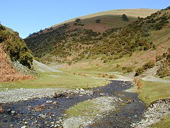
The brook flowing through Ashes Hollow valley
|
|
| Country | England |
| Counties | Shropshire |
| Physical characteristics | |
| Main source | Long Mynd 475 m (1,558 ft) |
| River mouth | Wistanstow, Shropshire 52°27′14″N 2°49′53″W / 52.4538°N 2.8313°W |
| Length | 14.5 km (9.0 mi) |
| Basin features | |
| Basin size | 89 km2 (34 sq mi) |
The Quinny Brook is a small river, also called a stream. It flows into a bigger river called the River Onny. You can find the Quinny Brook in the Shropshire Hills Area of Outstanding Natural Beauty in England. This area is known for its beautiful landscapes.
Contents
The Journey of Quinny Brook
The Quinny Brook starts its journey from a natural spring. This spring is called Boiling Well. It is located on the Long Mynd, which is a high, flat area with deep valleys. Close to the spring, you can see ancient burial mounds called Long barrows.
Flowing Through Valleys and Villages
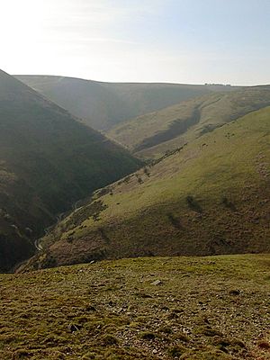
From its source, the brook flows southeast. It travels through a special V-shaped valley known as Ashes Hollow. This valley is narrow and deep, shaped by the water over many years. The brook then reaches the village of Little Stretton.
After Little Stretton, the water continues south. It passes near the villages of Marshbrook and Strefford. North of Strefford, another important stream joins it. This stream is called the Byne Brook.
Joining the River Onny
Once the Byne Brook joins, the Quinny Brook becomes larger. It flows through Strefford and then southwest towards The Grove and Berrymill cottage. Finally, south of Wistanstow, the Quinny Brook meets and joins the River Onny. The Quinny Brook is about 8.7 miles (14 km) long in total.
Understanding the Drainage Basin
The area of land that collects water for the Quinny Brook is called its drainage basin. This basin covers about 89 square kilometres (34 sq mi). It is located between the drainage basins of the River Onny to the west, the Cound Brook to the east, and the River Corve to the south.
Byne Brook: Quinny's Main Helper
The Byne Brook is the most important stream that flows into the Quinny Brook. It travels through an area called Ape Dale, which is at the bottom of a long hill known as Wenlock Edge.
Byne Brook's Path
The Byne Brook starts near Rushbury, where it is known as Lakehouse Brook. As it passes the village of Eaton-under-Heywood, it is also called Eaton Brook. The Byne Brook is 8.9 miles (14.3 km) long. Its own drainage basin covers about 53 square kilometres (20 sq mi). This means the Byne Brook contributes almost two-thirds of all the water that flows into the Quinny Brook!
Ecology: How Healthy are the Brooks?
The Quinny and Byne brooks are important for local wildlife. Experts check their health using something called the Water Framework Directive. This is a plan to make sure rivers and lakes are clean and healthy.
Water Quality Ratings
The brooks have been given a "moderate ecological quality" rating. This is the middle level on a scale that goes from "high" (very healthy) to "bad" (very unhealthy). A "moderate" rating means the brooks are doing okay, but there's always room for improvement to make them even better for plants and animals.
 | Jackie Robinson |
 | Jack Johnson |
 | Althea Gibson |
 | Arthur Ashe |
 | Muhammad Ali |


