Quiriquina Island facts for kids
|
Native name:
Isla Quiriquina
|
|
|---|---|
 |
|
| Geography | |
| Coordinates | 36°37′33″S 73°03′39″W / 36.625768°S 73.060805°W |
| Adjacent bodies of water | Pacific ocean |
| Total islands | 1 |
| Area | 4.86 km2 (1.88 sq mi) |
| Length | 5.3 km (3.29 mi) |
| Width | 1.6 km (0.99 mi) |
| Highest point | 120 |
| Administration | |
| Region | Bío Bío |
| Province | Concepción |
| Commune | Talcahuano |
| Additional information | |
| NGA UFI -898520 | |
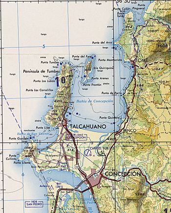
Quiriquina Island is a small island in Chile. It is located right at the entrance of the Bay of Concepción. The island is about 11 kilometers (7 miles) north of the city of Talcahuano. The name Quiriquina comes from the Mapuche language, and it means "many True thrushes."
Contents
History of Quiriquina Island
Quiriquina Island has played an important role in Chile's history, from ancient conflicts to modern times.
Early History and the Arauco War
In April 1557, a Spanish governor named Don Garcia de Mendoza arrived in Concepción. He brought many soldiers with him. He decided to set up his base on Quiriquina Island. From here, he led his military actions against the Mapuche people. This was part of a long conflict known as the Arauco War.
Charles Darwin's Visit in 1835
In 1835, a famous scientist named Charles Darwin visited Quiriquina Island. He was traveling around the world on a ship called HMS Beagle. His visit happened shortly after a big earthquake hit the nearby city of Concepción. Darwin studied the island's geology and nature during his time there.
Quiriquina Island During World War I
During the First World War, the Chilean government used Quiriquina Island for a special purpose. They held the crew members of a German warship called SMS Dresden on the island. One of the people held there was a lieutenant named Wilhelm Canaris. He later managed to escape from the island with two other crew members.
The Island as a Detention Center (1973-1975)
After the 1973 Chilean coup d'état (when the military took control of the government), Quiriquina Island was used as a place to hold people. The government at the time, led by Augusto Pinochet, used the island to detain political prisoners. These were people from Concepción and the Bío Bío Region who were seen as opponents of the new government. This detention center was active from September 11, 1973, until April 1975.
Island Features
Quiriquina Island has a few notable features. On the northwest side of the island, there is a lighthouse. Lighthouses help guide ships safely. To the southeast, you can find Fort Rondizzoni. This fort had buildings for guards, including places to sleep, eat, and get medical care.
See also
 In Spanish: Isla Quiriquina para niños
- Quiriquina Formation
 | Laphonza Butler |
 | Daisy Bates |
 | Elizabeth Piper Ensley |

