
Talcahuano facts for kids
Quick facts for kids
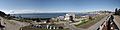
Talcahuano
|
|||||
|---|---|---|---|---|---|
 |
|||||
|
|||||
| Country | |||||
| Region | |||||
| Province | Concepción | ||||
| Founded | 1764 | ||||
| Government | |||||
| • Type | Municipality | ||||
| Area | |||||
| • City, Port and Commune | 92.3 km2 (35.6 sq mi) | ||||
| Elevation | 1 m (3 ft) | ||||
| Population
(2012 Census)
|
|||||
| • City, Port and Commune | 150,499 | ||||
| • Density | 1,630.5/km2 (4,223.1/sq mi) | ||||
| • Metro | 250,348 | ||||
| • Urban | 248,964 | ||||
| • Rural | 1,384 | ||||
| Demonym(s) | Talcahuian | ||||
| Sex | |||||
| • Men | 121,778 | ||||
| • Women | 128,570 | ||||
| Time zone | UTC−4 (CLT) | ||||
| • Summer (DST) | UTC−3 (CLST) | ||||
| Area code(s) | 56 + 41 | ||||


Talcahuano is a port city and a commune in the Biobío Region of Chile. It is part of a larger city area called Greater Concepción. Talcahuano is located in the southern part of Chile's Central Zone. Its name comes from the Mapuche language, Mapudungun, and means "Thundering Sky".
Contents
- Where is Talcahuano Located?
- How Many People Live in Talcahuano?
- A Look Back at Talcahuano's History
- What is Talcahuano's Economy Like?
- How is Talcahuano Governed?
- Culture and Sports in Talcahuano
- Talcahuano in Books
- Famous People from Talcahuano
- What is the Weather Like in Talcahuano?
- Images for kids
- See also
Where is Talcahuano Located?
Talcahuano is one of eleven municipalities in the Concepción Province. This province is one of four that make up the Biobío Region in Chile.
How Many People Live in Talcahuano?
In 2002, a study by the National Statistics Institute showed that Talcahuano covered about 145.8 square kilometers. At that time, 250,348 people lived there. Most of these people (99.4%) lived in city areas, while a small number (0.6%) lived in the countryside. The city's population grew a lot between 1992 and 2002, by almost 60%. This makes Talcahuano the seventh most populated city in Chile.
A Look Back at Talcahuano's History
Talcahuano officially became a port on November 5, 1764. This was declared by Antonio de Guill y Gonzaga. However, the area was known much earlier.
Early Discoveries and Forts
In 1544, a captain named Juan Bautista Pastene explored the coast. He discovered the mouth of the Biobío river, which is near Talcahuano. Later, in 1601, Alonso de Ribera built Fort Talcahueno. This fort helped protect Spanish settlements nearby.
The city gets its name from an Araucanian chief named Talcahueñu. He lived in the area when the Spanish first arrived.
Whaling and Earthquakes
In the 1800s, Talcahuano was a popular stop for American whaling ships. They would visit to get fresh water, food, and for their crews to relax.
On January 24, 1939, a very strong earthquake hit the city. It was an 8.3 magnitude quake. Many main buildings in Talcahuano were destroyed. There was little power, food, or water left. The British Navy helped by sending two ships, HMS Ajax and HMS Exeter. Their crews helped clear rubble, rescue people, and take the injured to safety.

The 2010 Earthquake and Tsunami
On February 27, 2010, Talcahuano was hit by another huge disaster. An 8.8 magnitude earthquake struck, followed by a tsunami. These events caused a lot of damage. About 80% of the city's residents lost their homes. The tsunami waves were estimated to be over 7.5 feet high.
After a week, 20 people were reported to have died, and 18 were missing. The city government believed it would take ten years to fully recover. They chose to build permanent homes instead of setting up long-term tent camps.
What is Talcahuano's Economy Like?
Talcahuano is very important for Chile's economy. It has the country's main naval base. This base is home to the historic ship, the Huáscar. This ship was captured in 1879 during the War of the Pacific. Talcahuano is also where Chile's submarine fleet is based. The ASMAR shipyard is also located here, where ships are built and repaired.
The city's economy also includes tourism, especially for its seafood. Its bay is great for boating. Industry, trade, and logistics are also big parts of Talcahuano's growth.
How is Talcahuano Governed?
Talcahuano is a commune, which is a local government area in Chile. It is managed by a municipal council. The head of the council is an alcalde (mayor), who is chosen by the people every four years. The mayor from 2016 to 2020 was Henry Campos Coa.
The commune of Talcahuano has seventeen different areas called districts. The three largest districts by population are Carriel, San Vicente, and San Miguel. Only a few districts have people living in rural areas.
- El Portón
- Valdivieso
- Cerro Fuentes
- La Aduana
- Cerro Buenavista
- Tumbes
- Isla Quiriquina
- San Vicente
- Estadio
- Huachipato
- Estadio Higueras
- San Miguel
- El Arenal
- Carriel
- Las Salinas
- Barranquilla
- Zunico
Culture and Sports in Talcahuano
Talcahuano has a special place in football history. In 1914, a player named Ramón Unzaga Asla invented the famous bicycle kick here. This move is also known as "chilena." The city is home to Club Deportivo Huachipato, a football club that plays in Chile's top league. Their home stadium is Estadio CAP.
Talcahuano is also the birthplace of Sammis Reyes. He used to play for Chile's national basketball team. Later, he switched to American football. In 2021, he became the first Chilean to play in the National Football League (NFL) in the United States.
Talcahuano in Books
Talcahuano has been mentioned in several famous books:
- It is a key location in Miles Smeeton's book Once Is Enough, a classic story about sailing.
- The character Charlie Marlow mentions it in Joseph Conrad's book Lord Jim.
- A chapter of In Search of the Castaways by Jules Verne takes place in its bay.
Famous People from Talcahuano
- Francisco Varela (1946–2001), a biologist and philosopher, was born here.
- Juan Onofre Chamorro (1885–1941), a leader for workers' rights, was also born here.
What is the Weather Like in Talcahuano?
| Climate data for Talcahuano | |||||||||||||
|---|---|---|---|---|---|---|---|---|---|---|---|---|---|
| Month | Jan | Feb | Mar | Apr | May | Jun | Jul | Aug | Sep | Oct | Nov | Dec | Year |
| Mean daily maximum °C (°F) | 21.5 (70.7) |
21.3 (70.3) |
19.9 (67.8) |
17.4 (63.3) |
14.6 (58.3) |
12.7 (54.9) |
12.2 (54.0) |
13.0 (55.4) |
14.3 (57.7) |
15.7 (60.3) |
17.8 (64.0) |
20.1 (68.2) |
16.7 (62.1) |
| Daily mean °C (°F) | 16.5 (61.7) |
16.1 (61.0) |
14.6 (58.3) |
12.8 (55.0) |
11.3 (52.3) |
9.8 (49.6) |
9.2 (48.6) |
9.4 (48.9) |
10.3 (50.5) |
11.6 (52.9) |
13.4 (56.1) |
15.4 (59.7) |
12.5 (54.6) |
| Mean daily minimum °C (°F) | 11.7 (53.1) |
11.3 (52.3) |
10.4 (50.7) |
9.3 (48.7) |
8.4 (47.1) |
6.9 (44.4) |
6.5 (43.7) |
6.4 (43.5) |
7.1 (44.8) |
7.8 (46.0) |
9.2 (48.6) |
10.7 (51.3) |
8.8 (47.8) |
| Average precipitation mm (inches) | 17.4 (0.69) |
15.7 (0.62) |
35.4 (1.39) |
73.7 (2.90) |
197.2 (7.76) |
220.5 (8.68) |
204.5 (8.05) |
163.6 (6.44) |
90.2 (3.55) |
53.9 (2.12) |
35.3 (1.39) |
24.9 (0.98) |
1,132.3 (44.57) |
| Average relative humidity (%) | 73 | 77 | 80 | 84 | 89 | 89 | 89 | 88 | 85 | 83 | 81 | 76 | 83 |
| Source: Bioclimatografia de Chile | |||||||||||||
| Climate data for Punta Tumbes | |||||||||||||
|---|---|---|---|---|---|---|---|---|---|---|---|---|---|
| Month | Jan | Feb | Mar | Apr | May | Jun | Jul | Aug | Sep | Oct | Nov | Dec | Year |
| Mean daily maximum °C (°F) | 18.7 (65.7) |
18.7 (65.7) |
17.8 (64.0) |
16.1 (61.0) |
14.6 (58.3) |
13.2 (55.8) |
13.0 (55.4) |
13.1 (55.6) |
13.9 (57.0) |
15.0 (59.0) |
16.1 (61.0) |
17.7 (63.9) |
15.7 (60.2) |
| Daily mean °C (°F) | 15.1 (59.2) |
15.5 (59.9) |
14.2 (57.6) |
12.7 (54.9) |
11.6 (52.9) |
10.2 (50.4) |
9.9 (49.8) |
9.7 (49.5) |
10.4 (50.7) |
11.4 (52.5) |
12.7 (54.9) |
14.2 (57.6) |
11.5 (52.7) |
| Mean daily minimum °C (°F) | 11.5 (52.7) |
11.5 (52.7) |
10.8 (51.4) |
9.8 (49.6) |
8.7 (47.7) |
7.4 (45.3) |
6.9 (44.4) |
6.7 (44.1) |
7.2 (45.0) |
8.2 (46.8) |
9.3 (48.7) |
10.6 (51.1) |
9.0 (48.3) |
| Average precipitation mm (inches) | 11.0 (0.43) |
9.7 (0.38) |
28.7 (1.13) |
60.9 (2.40) |
145.5 (5.73) |
159.4 (6.28) |
147.5 (5.81) |
115.2 (4.54) |
69.2 (2.72) |
34.1 (1.34) |
27.8 (1.09) |
19.7 (0.78) |
828.7 (32.63) |
| Average relative humidity (%) | 81 | 83 | 81 | 86 | 86 | 87 | 87 | 85 | 84 | 84 | 83 | 83 | 84 |
| Source: Bioclimatografia de Chile | |||||||||||||
Images for kids
-
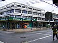
Center of Talcahuano
-
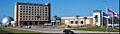
Casino of Talcahuano
-
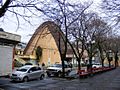
Church of Talcahuano
-
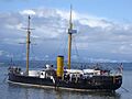
Monitor Huáscar
-
View of Port


See also
 In Spanish: Talcahuano para niños
