
Río Grande de Arecibo facts for kids
Quick facts for kids Arecibo River |
|
|---|---|

Río Grande de Arecibo
|
|
| Commonwealth | Puerto Rico |
| Municipality | Arecibo, Utuado |
| Physical characteristics | |
| Main source | Depending on the definition near Utuado Pueblo at the junction of the Viví and the Pellejas Rivers or Dos Bocas Lake between Arecibo and Utuado 18°28′22″N 66°42′38″W / 18.47278°N 66.71056°W |
| River mouth | Arecibo Bay in the Atlantic Ocean near Arecibo Pueblo |
| Length | 52.89 km (32.86 mi) |
| Basin features | |
| Tributaries |
|
The Río Grande de Arecibo (also called the Arecibo River) is an important river in Puerto Rico. It starts high up in the mountains south of Adjuntas. From there, it flows north, making its way to the Atlantic Ocean near the town of Arecibo.
This river is about 52.89 kilometers (32.86 miles) long. It flows through the middle of Puerto Rico. Along its path, it carves out a deep gorge. This gorge can be 200 meters (656 feet) deep. It is also quite wide, between 800 and 1,200 meters (2,625 to 3,937 feet).
Many smaller rivers and streams join the Arecibo River. These smaller rivers are called tributaries. They add water to the main river. Some of these tributaries start near Cerro de Punta, which is the highest mountain in Puerto Rico.
Contents
Understanding the River's Tributaries
A tributary is a stream or river that flows into a larger stream or river. The Arecibo River has many tributaries. These smaller rivers help form the larger Arecibo River system.
Some of the rivers that flow into the Río Grande de Arecibo include:
- Vacas River
- Pellejas River
- Garzas River
- Saltillo River
- Cidra River
- Grande de Jayuya River
- Caguana River
- Caonillas River
- Yunés River
- Limón River
- Jauca River
- Tanamá River
- Santiago River
Protecting the River from Floods
Rivers can sometimes overflow their banks, causing floods. To prevent this, special projects are put in place. In 2018, the United States Army Corps of Engineers started a big project for the Arecibo River. This project aimed to control floods and protect the areas around the river. The budget for this important work was $82.9 million.
Later, in 2021, more money was set aside for the river. This funding was used for two main things. First, it helped improve the natural home (habitat) for local animals. This included helping the Puerto Rican crested toad. Second, a project to make a special channel (canalization) for the river was planned. This work was set to begin in 2023.
Images for kids
-
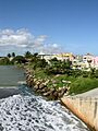
View of Arecibo from the mouth of Río Grande de Arecibo
-
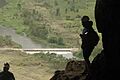
View of the river from Cueva Ventana
-
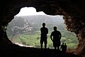
Río Grande de Arecibo from Cueva Ventana after it rained


See also
 In Spanish: Río Grande de Arecibo para niños
- Cambalache Bridge: A historic bridge in Arecibo, Puerto Rico.
- List of rivers of Puerto Rico: A list of other rivers found in Puerto Rico.
