Rüfenach facts for kids
Quick facts for kids
Rüfenach
|
||
|---|---|---|
 |
||
|
||
| Country | Switzerland | |
| Canton | Aargau | |
| District | Brugg | |
| Area | ||
| • Total | 4.17 km2 (1.61 sq mi) | |
| Elevation | 374 m (1,227 ft) | |
| Population
(Dec 2020 )
|
||
| • Total | 863 | |
| • Density | 207.0/km2 (536.0/sq mi) | |
| Postal code |
5235
|
|
| Localities | Rüfenach, Hinterrein, Vorderrein | |
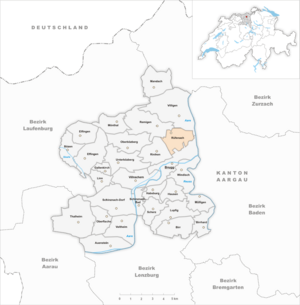
| Surrounded by | Brugg, Remigen, Riniken, Villigen | |
Rüfenach is a small town, also called a municipality, in Switzerland. It is located in the Brugg area of the canton of Aargau.
Contents
Exploring Rüfenach's Location and Landscape
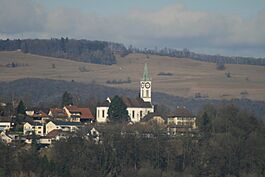
Rüfenach is nestled at the base of two hills, the Bruggerberg and the Reinerberg. These hills are part of the southeastern edge of the Jura Mountains.
The municipality is made up of three villages: Rüfenach, Hinterrein, and Vorderrein. Before 1898, Hinterrein and Vorderrein were part of a separate municipality called Rein. Rüfenach is the westernmost village, located on a flat plain. Hinterrein is a bit higher up, in the middle. Vorderrein is to the east, on a noticeable hill. This hill drops sharply down to the Aare river on its eastern side. The height difference between the top of the hill and the river is about 70 meters (230 feet).
Land Use in Rüfenach
Rüfenach covers an area of about 4.17 square kilometers (1.61 square miles). A large part of this land, about 47.5%, is used for farming. Forests cover another big portion, about 40.8% of the area. The remaining land, about 11.5%, is built up with buildings and roads. A tiny part, 0.5%, is made up of rivers or lakes.
Most of the built-up area is for homes and other buildings (4.8%). Roads and other transport areas make up 5.8%. About 40% of the total land is covered by thick forests. For farming, 35.7% is used for growing crops. Another 8.2% is used for pastures where animals graze. About 3.6% is used for fruit trees or vineyards. All the water in Rüfenach is found in its rivers and streams.
The highest point in Rüfenach is the Reinerberg, which is 522 meters (1,713 feet) high. The lowest point is in Vorderrein, by the Aare river, at 325 meters (1,066 feet).
Neighboring Towns
Rüfenach is surrounded by other municipalities. To the north and northeast is Villigen. To the southeast is Brugg. Riniken is to the southwest, and Remigen is to the northwest.
A Look Back at Rüfenach's History
Since the 700s, the area of Rein was an important center with its own court. This court belonged to a monastery called Murbach in France. The area also included Rüfenach and other nearby villages. Rüfenach itself was first mentioned in old writings between 1227 and 1234.
Changes in Power Over Time
In the 1200s, the Habsburg family, who were powerful rulers, started to control this region. King Rudolph I of Habsburg bought Rein in 1291. Later, in 1345, Queen Agnes of Hungary gave Rein to another monastery in Germany.
When the city of Bern took over the area west of the Aare river in 1460, the monastery's rights were not affected. However, a big change came with the Reformation in 1528. This was a time when many people changed their religious beliefs. In 1544, the monastery sold Rein to Count Hartmann von Hallwyl. Between 1588 and 1599, the city of Brugg gained control of two-thirds of the land, and Bern controlled the other third.
Rüfenach in Modern Times
In March 1798, France conquered Switzerland and created a new government called the Helvetic Republic. Rein became part of the new canton of Aargau. In 1799, during the Napoleonic Wars, the battle line between armies ran through the Aare valley. Villagers suffered a lot from soldiers taking their supplies and valuables.
In 1803, Rein was split up, and its villages became independent municipalities. About 100 years later, the canton wanted to combine small towns. Rein was merged with Rüfenach. The people of Rein tried to stop this, but they were not successful. Even after going to the highest court, the two municipalities were officially united on January 1, 1898.
Until the mid-1900s, Rüfenach and Rein were mostly farming villages. But in the 1960s, a lot of new buildings were constructed. This caused the population to more than double!
Rüfenach's Coat of Arms
The blazon (description) of Rüfenach's municipal coat of arms is simple: it shows a golden bundle of grain on a blue background.
Buildings and Landmarks
The Church of Rüfenach
The church, which was once the main building in the area, dates back to the 800s. It had features from both Romanesque and Gothic styles. Sadly, it had to be torn down in 1863 because it was no longer safe. A new church was built in its place in 1864. It was designed by an architect from Zürich named Johann Kaspar Wolf.
Other Important Buildings
In 1814, a textile businessman named Johann Heinrich Meyer started an orphanage and a home for the poor. This building, built in a classical style, later became part of the cantonal psychiatric hospital in 1947.
Who Lives in Rüfenach?
Rüfenach has a population of 863. About 10.2% of the people living here are from other countries. Over the past ten years (1997–2007), the population grew by about 23.6%. Most people in Rüfenach (94.9%) speak German. Portuguese and Albanian are the next most common languages, each spoken by about 1.1% of the population.
Age Groups in Rüfenach
Looking at the age of people in Rüfenach:
- About 9.3% are children aged 0 to 9 years old.
- About 16.3% are teenagers aged 10 to 19.
- About 10.9% are young adults aged 20 to 29.
- About 10.8% are aged 30 to 39.
- About 19.7% are aged 40 to 49.
- About 14.7% are aged 50 to 59.
- About 11.4% are aged 60 to 69.
- About 4.5% are aged 70 to 79.
- About 2.0% are aged 80 to 89.
- A small number, 0.3%, are 90 years old or older.
Homes and Education
In 2000, there were many homes with 3 or more people living in them. The average household had about 2.75 people. In 2008, most homes (62.1%) were single-family houses. Only a few apartments (1.2%) were empty. In 2007, new housing was being built at a rate of 10.7 new homes for every 1000 residents.
In Rüfenach, about 81.6% of adults (aged 25–64) have finished high school or gone on to higher education, like university. In the 2008/2009 school year, there were 90 students in primary school and 127 students in secondary school in the municipality.
Historical Population Trends
The population of Rüfenach has changed over the years:
- 1764: 124 people
- 1888: 276 people
- 1900: 266 people
- 1950: 272 people
- 2000: 727 people
Rüfenach's Economy
In 2007, Rüfenach had a low unemployment rate of 1.84%. In 2005, 55 people worked in farming, and there were 17 businesses related to farming. Only 3 people worked in manufacturing, with 2 businesses in this area. The largest number of people, 105, worked in the service industry (like shops, offices, or healthcare), with 18 businesses.
In 2000, 386 people who lived in Rüfenach had jobs. Most of them (about 75.6%) worked outside of Rüfenach. However, 90 people came into Rüfenach for work. There were 184 jobs available in the municipality. For getting to work, 14.6% of people used public transportation, and 49.9% used a private car.
Religious Life
According to the 2000 census, about 28.9% of the people in Rüfenach were Roman Catholic. A larger group, about 54.6%, belonged to the Swiss Reformed Church. A very small number (0.41%) were part of the Christian Catholic faith.
Getting Around Rüfenach
The main highway that connects Stilli to Remigen and Laufenburg passes just north of Rüfenach. For public transportation, a post bus line runs from Brugg to Mönthal, providing service to the municipality.
Famous People from Rüfenach
- Paul Haller: A well-known author who lived from 1882 to 1920.
See also
 In Spanish: Rüfenach para niños
 | Kyle Baker |
 | Joseph Yoakum |
 | Laura Wheeler Waring |
 | Henry Ossawa Tanner |


